|
Location:
Salisbury, England.
(O/S -
SU 098 700). |
Grid Reference: 51� 25' 40''
N, 1� 51' 6" W. |
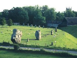
 Avebury:
(Henge Circle).
Avebury:
(Henge Circle).
 The
largest Henge-circle in the world. The
largest Henge-circle in the world.
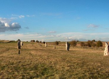
Avebury
is the largest stone
circle in the world:
it is 427m (1401ft) in diameter and covers an area of about 28 acres (11.5 ha).
The site is formed by a huge circular bank (roughly a mile
around), a massive ditch, now only a half its original depth, and a
great ring of 98 sarsen slabs enclosing two smaller circles of 30 stones
each and other settings and arrangements of stones.
Burl mentions evidence
of a
third inner circle (see
below), but
so little remains that it is commonly forgotten as a part of the complex.
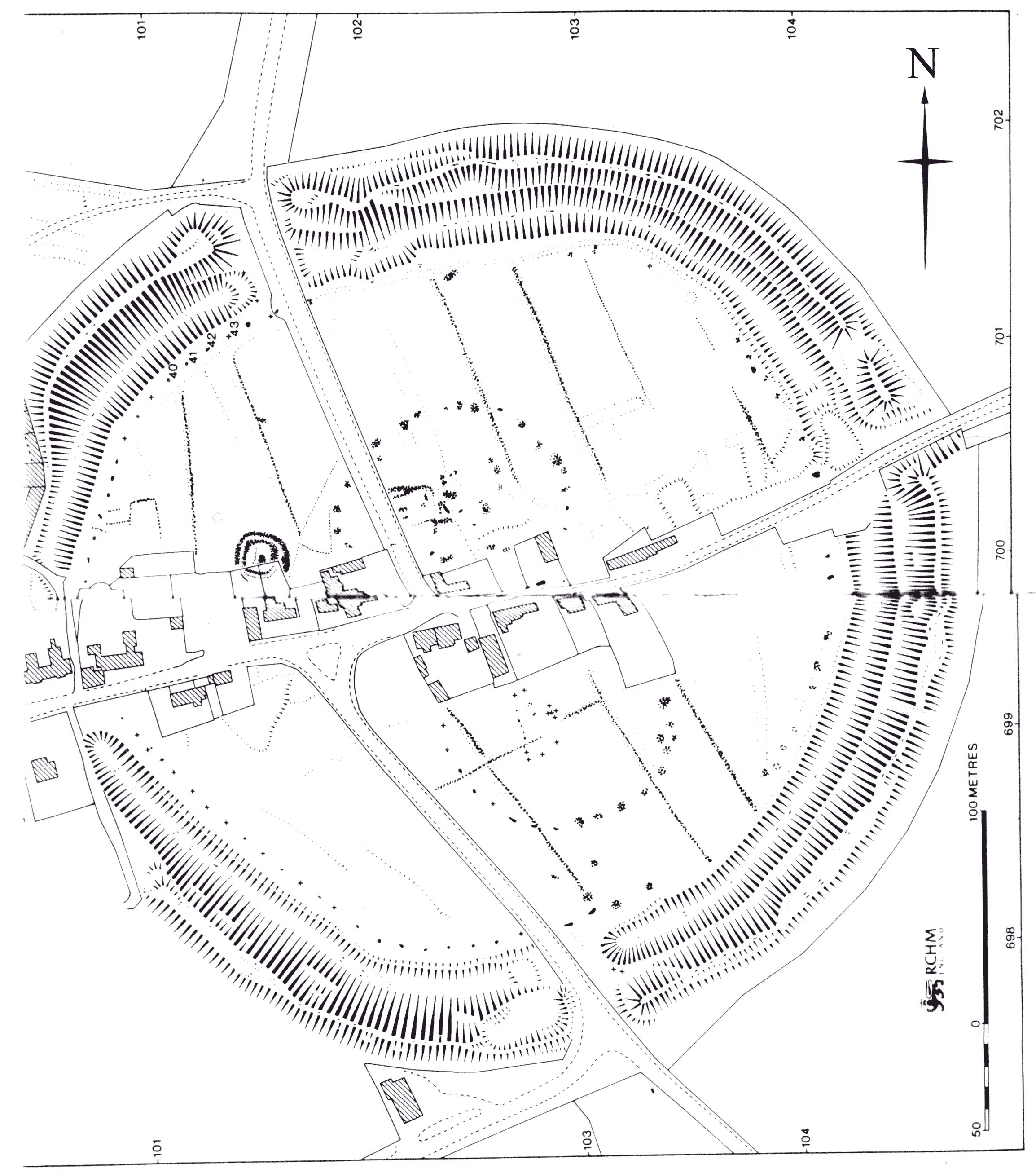
(Click here for
Ground-plan of
Avebury)
|
Avebury - A Physical Description: |
The Henge
and Ditch:

When originally built the bank would have been
something like 27 metres wide at the base and 6 metres high. The
ditch
was 9 metres deep and some 14 metres wide at the top, tapering to less than
half that at the bottom. There were entrance causeways at the north, south,
east and west.
The
henge is formed by a boundary ditch 15m (50ft) deep which runs between the
outer bank and the great stone circle -
The outer bank was originally 17m
(55ft) high from ditch bottom to bank top and has a perimeter of over 1km.
There are four entrances to the henge's bank and ditch. From the southern entrance
a double avenue of standing stones called the Kennet
Avenue, originally ran for
2.4 km and ended in two small stone circles and several circular wooden
buildings. From another
entrance ran
the Beckhampton Avenue,
2km long, which once contained about 200 stones, of which
only one is left
standing today. Other important sites close by are
Stonehenge,
Windmill hill, a
causewayed camp built in 3,350 BC before Avebury was built, Also
Silbury hill, Europe's tallest
artificial mound, and England's largest prehistoric tomb, the 104m (340ft)
long
West Kennet long barrow.
The design of the bank and ditch (with the ditch built on the inside) has
led to speculation that the bank might have served as a viewing platform,
allowing multitudes of people to observe events inside the henge, without
allowing them entry.
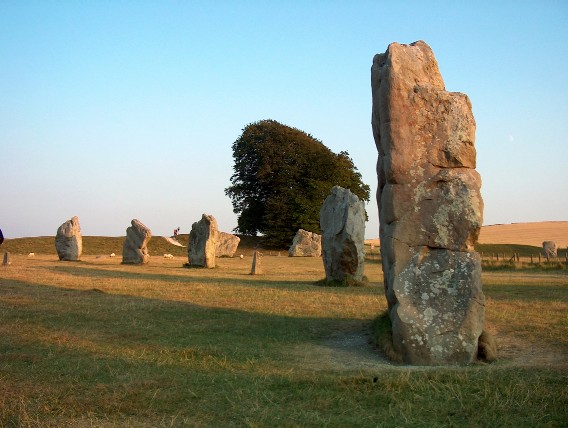
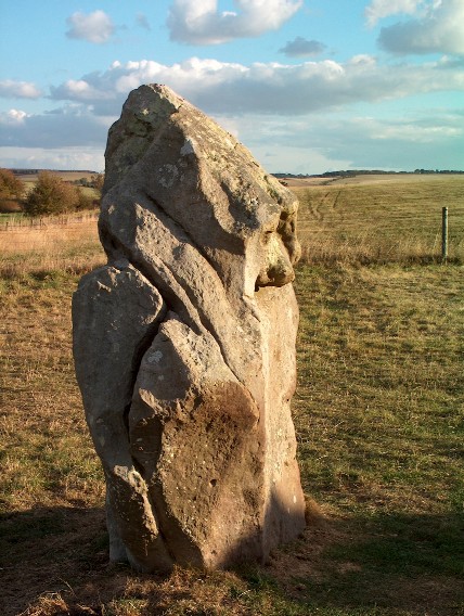
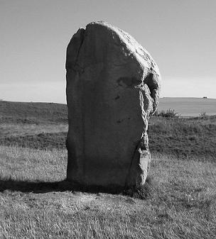
The Outer Stone-Circle:
The stones for the large stone circle each weighing about 40 tons or
more, were left rough and not dressed (as the Stonehenge blocks were). The
outer circle originally consisted of 98 stones (There are 98 lunar cycles
each 8 solar years), which were obtained
from the nearby Marlborough Downs. Now there
are only 27 left, as many of the stones
were broken up in the past, and used to construct the present
village which grew up within the earthwork.
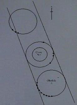
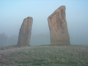
The Two
inner Circles:
There are two definite remaining stone circles
inside the larger site of Avebury. One is located in the Northern sector of
the Avebury ring and there are four of the 27 stones left today. The other
is in the Southern sector of the ring and has five of the original 29 stones
still standing.
The northern circle was once a
concentric circle, while the southern circle once had an obelisk
standing in the centre. the top of Silbury Hill is visible from the
height of the obelisk, so it would have been visible from Silbury.
|
The
Fourth Circle:
 Although it is not
commonly mentioned, a fourth circle has been
shown to have once existed at Avebury.
It was discovered in 1937 by 'A. Keiller', who found
three 'unrecorded
stone holes...eleven metres apart on the arc of a circle about 103m in
diameter, much the same as the 'North' and 'South' inner circles, whose stones were also placed about eleven
metres apart. Although it is not
commonly mentioned, a fourth circle has been
shown to have once existed at Avebury.
It was discovered in 1937 by 'A. Keiller', who found
three 'unrecorded
stone holes...eleven metres apart on the arc of a circle about 103m in
diameter, much the same as the 'North' and 'South' inner circles, whose stones were also placed about eleven
metres apart.
 The centre of this third circle was on the same
North-north-west to South-south-east axis as the others and Keiller
concluded that "it seems impossible therefore not to conclude that what
one may term as 'Avebury I' consisted of three settings of
stones...unaccompanied by banks or ditches". The centre of this third circle was on the same
North-north-west to South-south-east axis as the others and Keiller
concluded that "it seems impossible therefore not to conclude that what
one may term as 'Avebury I' consisted of three settings of
stones...unaccompanied by banks or ditches".
The phenomena of triple circles is not uncommon in the UK.
The three Thornborough Henges are
similarly aligned as are several triple-stone circles. In the case of
Thornborough, it has been suggested by Prof. Clive Ruggles, that they were
made to mirror the three stars of Orion's belt. A suggestion which has
also been claimed for the three pyramids at Giza.
(More
about Triple- Circles and Orion)
|
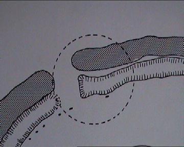
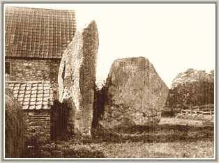 The Cove: The Cove:
Two of the central stones (once three), are called
The Cove, and may have been erected first, even before the great
circle. The same feature can be seen at
Arbor Low and
Stennes.
An attempt to straighten the
two stones called 'The Cove' in 2003, revealed the fact that one of the
stones, which stands 14ft (4.4m), above the ground, also exists at least 7ft
(2.2m) below the ground (reaching a possible 10ft/3m deep). The weight of
the stone is calculated at around 100 tons.
Refs: Daily Telegraph
News (8 April 2003); The Scotsman (17 April 2003)The Guardian (18 April
2003)
The
Avenues:
There were two ceremonial avenues of standing stones departing from the
main ring. Only one survives, the
West Kennet Avenue, which was
originally 2.5km (1.5 miles) in length and connected Avebury to the small
stone circle called The Sanctuary
on Overton Hill. The 'Beckhampton Way' leads east from Avebury, past
several long-barrows, original destination unknown. To the prehistoric
traveller however, arriving from the direction of the Ridgeway, it is
noticeable that Silbury hill is completely obscured for the whole of
the West-Kennet avenue, which is the natural route to Avebury from The
Sanctuary.
The West-Kennet Avenue was originally composed of a
hundred pairs of stones.
(Photo credits: 'Up in
smoke' ken).
The Stones are believed to have
alternated between 'Upright' and 'lozenge', possibly representing male
and female. The venue leads directly from the 'Sanctuary'
to Avebury. Although it was long disputed, evidence of
Stukeleys other avenue which he proposed led from Avebury
westwards has now been determined. The Beckhampton Avenue
would have originally been composed of at least another
hundred stones. Today, none exist in their original
settings.
For a long time the estimated date of construction was reckoned at
around 2,600 BC
(1)
Avebury�s largest megalith
may also be one of the UK�s oldest. A new date suggests it was erected around
3,000 BC, possibly before the surrounding earthwork and other stones.
Ref:
http://www.britarch.ac.uk/ba/ba76/news.shtml
The fact that there are
several monuments in the region which date from before its construction,
(Windmill hill 3,300 BC, West Kennet
3,500 BC etc), demonstrates that the area was in use long before the
structures we see now were present.
Gillings and Pollard
recently suggested that Avebury was not a structure for the ancestors, but
represents a carefully choreographed gathering of them.
(2)
The Destruction of the
Monument
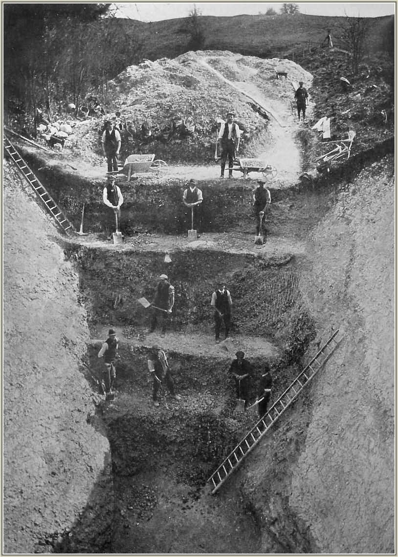
When William Stukeley visited Avebury in the 17th century he became
the unwitting witness to a period of wholesale destruction of the
Avebury sarsens, ironically in order to provide building materials
for the village and church that now stand within the complex.
Richard Colt
Hoare's survey in 1815 can be used to see how the site has been
systematically reduced over time. The site only became completely
protected when Alexander Keller became the owner in the 1930's.
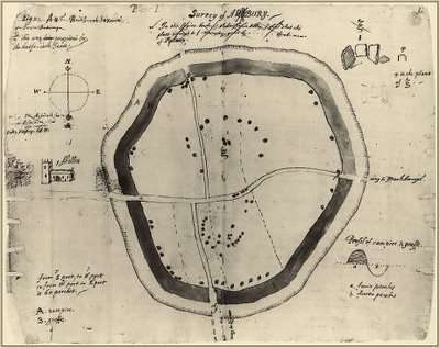
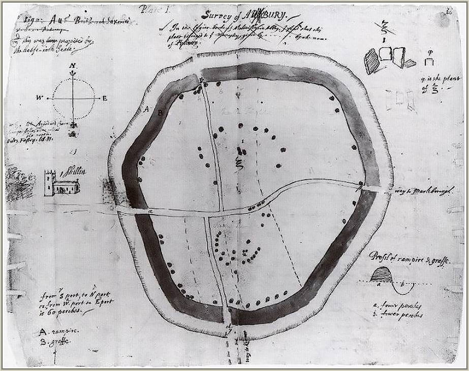
The earliest ground-plan of
Avebury by John Aubrey in 1663.
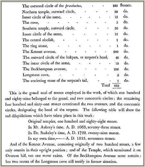
From an original estimate of over 600 stones for the main monument,
200 for the West-Kennet Avenue, and at least another hundred for the
Beckhampton avenue...
W e are left today with 27 at Avebury, and
just a
handful more along the West-kennet avenue...
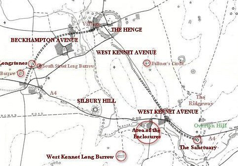
Avebury should not be viewed as a solitary
construction, but rather part of a larger, ceremonial landscape, attached to
other important nearby constructions such as Silbury Hill and the Sanctuary and
beyond.
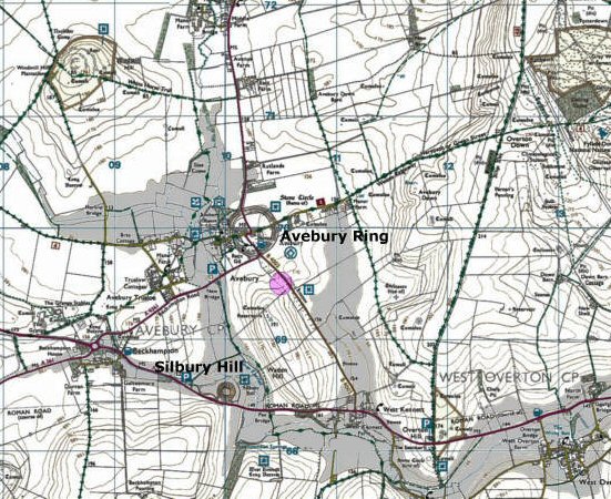
From the map below it can be seen that the Sanctuary
is not only placed in a bend of the river Avon, but sits on the
Ridgeway, so that anyone arriving from either direction would have
been naturally led to Avebury along the West Kennet Avenue (which would have
incidentally had the effect of
obscuring Silbury Hill behind 'Woden'/'Waden' Hill). In addition, the Beckhampton avenue also leads one
away from Silbury.
The Avebury/Silbury hill combination demonstrate the two basic
elements found at
several of other European complexes, namely a conical mound (suggested as symbolising
the 'mound of creation' and usually surrounded by water), and a prominent
nearby stone circle.
Although in this case the two are not inter-visible, their proximity and
dominance on the landscape leaves no doubt that they were both part of a larger
unified ceremonial landscape, connected with avenues and the natural folds of the
Wiltshire countryside. The projection below however, demonstrates how easily the
landscape can be changed and alters the whole context of Avebury/Silbury in the Process.
(Other Examples of Primal mound/Stone circles)
This map shows a projection for a 5m rise in the level of the
River Kennet, which has the effect of converting Silbury Hill into a permanent
island (which it arguably was always intended to be), and also brings the water to the very edge of Avebury itself, perhaps
explaining the large exterior bank and wide ditch, perhaps even useable for
small boats.
( More
about the Salisbury Complex)
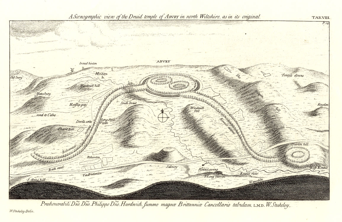
Stuckley on Avebury:
William Stukeley pioneered the archaeological
investigation of both Avebury and Stonehenge. He envisioned Avebury as part of a
huge druidic serpentine temple. Although today we know that it was built
long before the druids, his vision paved the way for a greater understanding of
the relationship between component megaliths in the area.
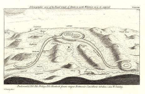
(Click on Image for larger view)
The Avebury circle is sited on the latitude 51.428� North, (Which is
also the result of 360�/7)
Avebury,
Stonehenge
and
Glastonbury form a right angled
triangle accurate to within 1/1000. The 'St.
Michaels'
ley-line from Glastonbury to Avebury coincides with the Mayday sunrise,
crossing the longest possible stretch of Southern Britain. The ley runs from
St. Michael's mount to Brent tor, Cadbury, Trull, Creech St Michael,
Lyng, Othery, Burrowbrigde, Glastonbury, Buckland dingham, Avebury,
Ogbourne St George, East Hendred and Bury St Edmonds (All these sites
have or had churches dedicated to the dragon-killing Saints Michael and
George).
From Salisbury plain, beginning at the southern end of the Avebury stone
circle and extending for 200 miles north-westward to Norfolk, is the
prehistoric highway called the 'Ikneild Way'. The road runs dead straight on
level ground and follows perfectly the contour of the land in hilly areas.
It has a level surface and widens at some places to the equivalent of a
modern four-lane highway. It pre-dates the Romans by 2000 yrs
(9). In addition, the Sanctuary is positioned
alongside the Ridgeway, which leads to the north and would have been one of
the most important prehistoric routes across Britain.
The
Sanctuary near Avebury has a longitude of 1� 49' west, the same as the
Stonehenge circle, 17
miles to the South.
The angle from Avebury
to the Sanctuary is 51� 51',
the same angle as the Avenue leading from Stonehenge, and the exterior angle
of the
Great Pyramid of Ghiza.
(Geodesy in Prehistoric Britain)
Avebury lies on the 'St.
Michaels'
ley-line which coincides with the Mayday sunrise, crossing the longest
possible stretch of Southern Britain. The ley runs from
St. Michael's mount to Brent tor, Cadbury, Trull, Creech St. Michael, Lyng, Othery, Burrowbrigde, Glastonbury, Buckland dingham, Avebury,
Ogbourne St George, East Hendred and Bury St Edmonds (All these sites
have or had churches dedicated to the dragon-killing Saints Michael and
George).
(More about the St. Michael's
Ley-line)
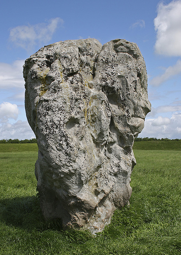
It has been noted
that there are some good examples of 'Simulacrum' at Avebury.
Although it is well known today that this effect is a natural
phenomena in people, finding a human image in stone would have
been likely to 'empower' it with 'magical' qualities. Faces such
as these are found at other other prominent UK megaliths such as
Stonehenge and
Brodgar.
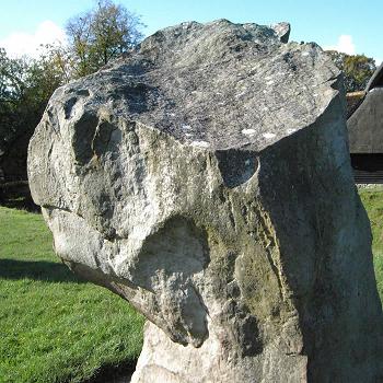
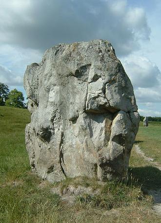
(Other Examples of Megalithic Simulacrum)
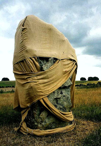
A
vandalised stone at Avebury... (1996).
(Other Desecrated
Megaliths)
(Stone Circles)
(Henges)
(Silbury Hill) (West
Kennet Long Barrow) (The
Sanctuary)
(The Salisbury Complex)
(Other European Megalithic Complexes)
(Prehistoric English Geodesy)
(Other Prehistoric English sites)
|