|
 European Megalithic Complexes:
(Form and Function)
European Megalithic Complexes:
(Form and Function)
A look at the
most prominent concentrations of European megalithic sites.
Household names such as the Orkney
Islands, Boyne Valley, Carnac, Salisbury and Malta, were all functioning at
the same period of time (c. 3,100 - 2,400 BC), at the height of the
Neolithic period. Although they are scattered over a thousand miles of
coastline, and cross several localised Neolithic regions, these
'complexes' are united by a set of specific and contemporary cultural
features, a fact which suggests that - at the very least, they offered a
common socio-religious experience to the people who lived alongside them.
The construction of so many grandiose complexes
at this time united
the Neolithic people in an important cultural way unseen
before in Europe. Their existence acted as a stabilising anchor, as
demonstrated by the fact that in many cases the very same locations
were re-used over and again for thousands of years. The development of such
large-scale construction programs also created a
requirement for specialised skills and crafts. But how are we to view these complexes
today. Were they the prehistoric equivalent of modern cities, Astro-religious
centres, what drove the western European Neolithic people to build so many
civil-scale structures, and how are we to understand such a choreographed event
through modern eyes.
| Examples
of European Mega-Complexes: |
The Following is a brief description of some of the better known
prehistoric European complex's.
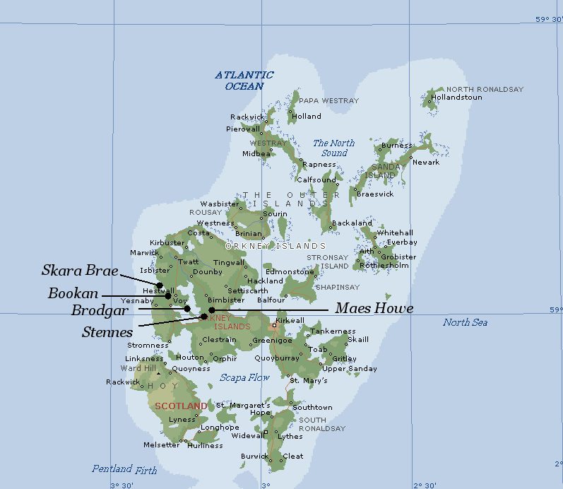
The Orkneys complex, Scotland.
(Includes Brodgar,
Stennes,
Maes Howe,
Skara Brae).
(Map of the Orkneys
Complex)
The Orkneys shows a
continuous Neolithic occupation from 3,500 onwards, with construction
work on Stennes, Skara Brae and Brodgar starting at around 3,100 BC
with Maes Howe being built soon after at around 2,800 BC. The Orkneys
resists the standard description of the priorities of Neolithic
communities in Europe at this time (in terms of survival), but is a classic example of a
'complex', perhaps being one of the last to be built by what appears
to be a northerly immigration along the Atlantic coast by people
casually termed 'Boat-people' or 'Grooved-ware-Beaker' people.
At the latitude of
the Orkneys the major lunar standstills north becomes almost
circumpolar, (neither rising nor setting - with the effect that the
moon 'rolls' along the horizon). Because the Earth�s axial tilt
has changed by nearly half a degree since the majority of the stone
circles were built, this effect is no longer accurate and the latitude today would have to be 63�
north for a lunar standstill north to be truly circumpolar (3)
Alexander Thom - 1969. Megalithic
Lunar Observatories.:
'The moon from the
Shetland Isles today is almost circumpolar, (when the moon is at its
furthest north). In megalithic times, because of the greater
obliquity - the moon from the high ground from northern parts of
Island would have been circumpolar'.
Thom noted that the natural
features in the surrounding landscape seemed to serve as distant
markers for the rising and setting of the moon. A sightline to the
cliffs of Hellia on Hoy, for example, seemed to mark the minor
southern setting of the moon, while a notch on Mid Hill, to the
south-east, defined the minor southern moonrise. (6)
The Orkneys'
'complex' is approximately 1.5�
lower in latitude than the Shetlands, so the the moon would have still
appeared to be partially circumpolar. Even today, Callanish on
the Hebrides (58� N), still shows a similar effect with the
Southern standstill.
(More about the Orkneys complex)
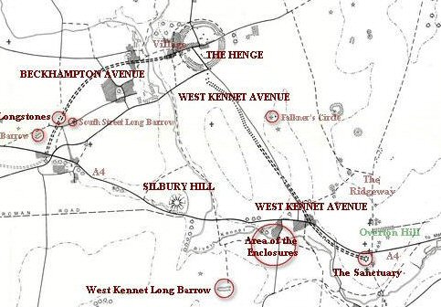
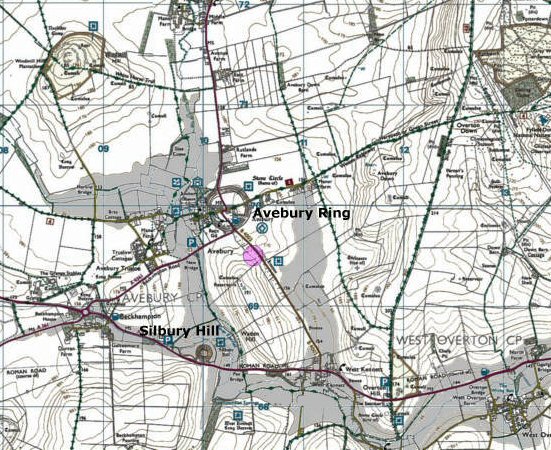
The Salisbury complex. England. -
(Includes
Avebury, Silbury Hill,
Sanctuary,
Stonehenge etc.. etc..)
(Map
of the Extended Salisbury Complex)
The area Windmill Hill Henge, West Kennet
and the Stonehenge Cursus all gave radiocarbon dates of around 3,500 BC.
Avebury began at around 3,000 BC, and the first phase of Silbury
Hill came a couple of hundred years later at around 2,750 �95 BC. The
significance of the location lies in its latitude, (51�
25' 40'' N, both
1/7th the circumference of a circle and 4/7th's of 90�). The monuments
around Avebury can be viewed as the Northern part of a super complex
which includes Stonehenge, Durrington Walls, Woodhenge and the
Cursus.
It is a curious
fact that
Stonehenge and the Sanctuary are separated by exactly 1/4 of a degree of latitude,
and both lie on the same line of longitude. The incorporation of
such an earthly measurement into two contemporary sites (The
Sanctuary being the start-point of the Avebury avenues, and
Stonehenge being at the end of the Southern avenue leading from the
River Avon. The separation of other prominent megaliths from
these two points by units of degrees, opens the debate that this
location was chosen to represent a prehistoric meridian.
(More
about the Salisbury Complex)
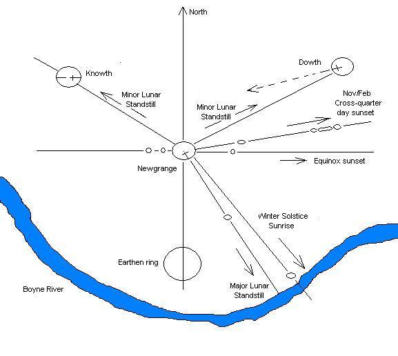
The Boyne Valley complex, Ireland.
(Includes: Newgrange,
Knowth,
Dowth)
(Map of the Boyne Valley Complex)
The radiocarbon dates
for the construction and use of Newgrange, Knowth and Dowth span nearly
half a millennium: (3,500 - 3,000 BC). As Ireland was already
populated by Neolithic passage-mound builders (such as
Carrowmore c. 4,600 BC), the specific
astronomical nature of these three mounds suggest that cumulative
knowledge and long term planning lie behind the layout of this ritual
centre, most probably dating back long before the construction of the
three major tombs. The Boyne-valley complex is intervisible with other
prominent megalithic sites such as: Tara
Hill, Loughcrew and
Four-knocks.
The site-to-site
bearing from the Avebury complex to Tara Hill, Ireland is 360/7.
In addition, Ireland shares another important geodetic relationship with
Avebury, which is that both the Newgrange and Avebury complexes possess
identically-sized stone circles of 103m (As does the ring of Brodgar on
the Orkneys).
(More about the
Boyne Valley)
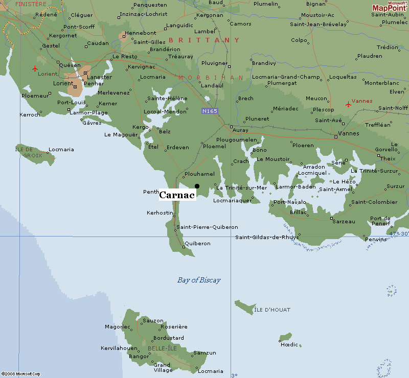
The Carnac complex, France.
(Includes
Le Grande
Menhir Brise, Table Des Marchands,
Er lannic,
Gavrinis).
(Map of Carnac
Complex)
The concentration of
Megaliths at Carnac and the surrounding area are considered the
greatest in all Europe. The region shows several specific periods of
activity, starting slightly earlier than the British counterparts with
the first at around 5,000 - 4,500 BC (Kercado
4,700 BC), when several large monuments were
erected such as the Kercado passage mound and the Dol de Breton
alignment for example. Noticeably, at around 3,300 -3,100 BC the
region experienced a wave of construction which included the re-use of
existing monuments (i.e. The cap-stones for the
Table-des-Marchands,
Gavr'inis and
Er-Lannic tumulii (c. 3,300 - 3,100
BC), are all parts of an
original menhir from the Grande Menhir construction). The new
constructions show several specific similarities with those built at
the same time in the Boyne Valley and on the Orkneys.
(More about the Locmariaquer
Menhirs)
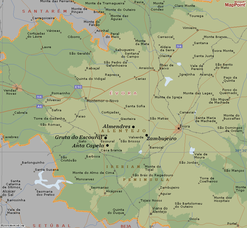
The Evora complex, Portugal.
(Includes Zambujeiro,
Almendres, Gruta da
Escoural).
(Map of Evora
Complex)
Home to the oldest
stone circles in western Europe, one of the most spectacular passage mounds,
and numerous other sites dating back to the Mesolithic, this region of
Portugal is now being called the 'Mesopotamia of Iberia'. The
Almendres stone circle shows different stages of development
through the 4th to 5th millennium BC.
The latitude of Evora has an astronomical
significance in that there
are only two latitudes at which the Moon's maximum declination is the
same as the latitude (meaning that at its maximum elongation it
goes through the zenith - directly overhead). These two latitudes
are 38˚ 33' N (Almendres), and 51� 10' N (Stonehenge).
(More about the Evora complex)
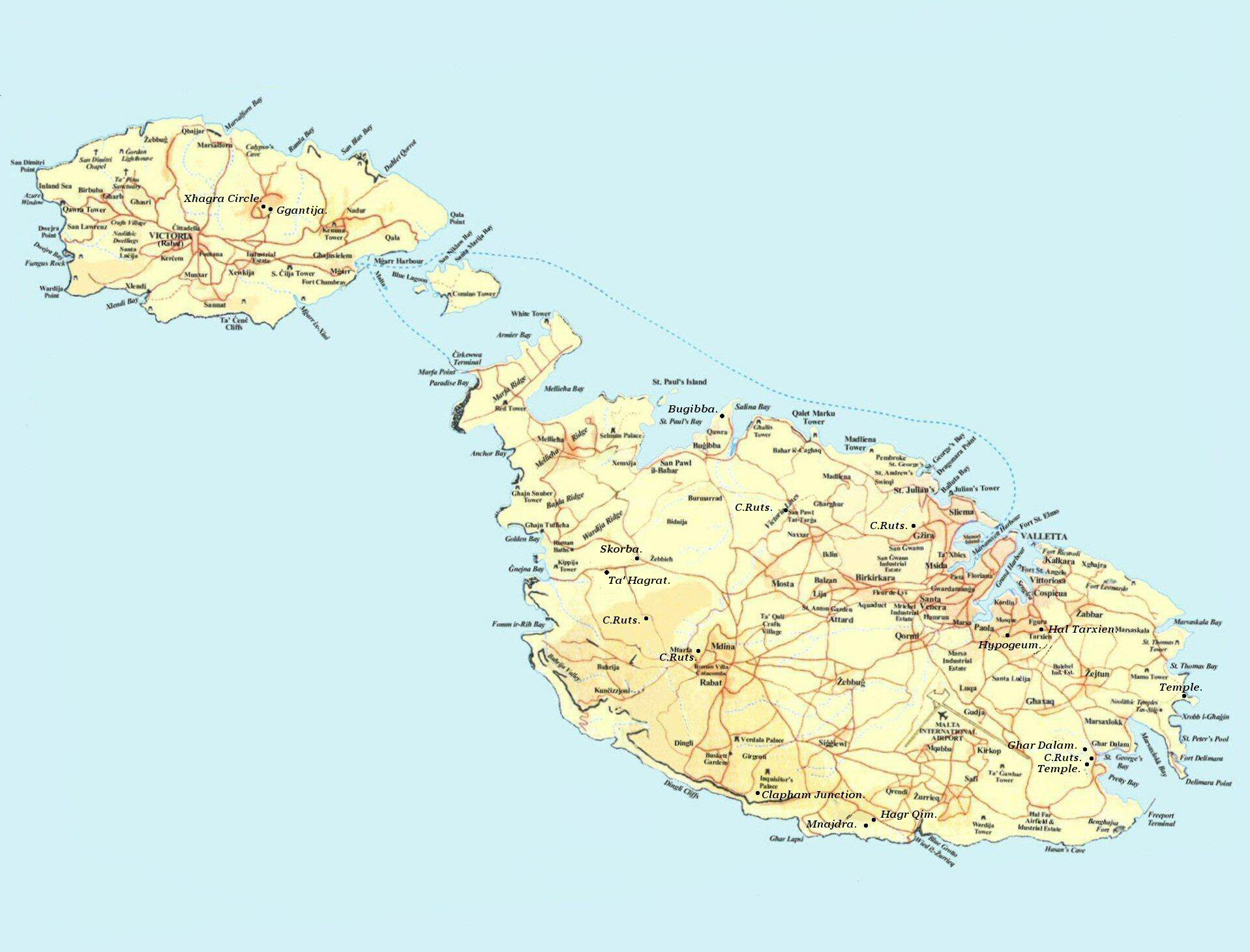
The Maltese complex.
(Includes Ggantija,
Tarxien, Hypogeum,
Hagar Qim).
(Map of Maltese Megaliths)
 The Island of Malta
served as a prehistoric complex for Earth-mother worship for well over a
thousand years. The isolatory nature of the island has made it a 'Petrie
dish' of prehistoric life for researchers. Regardless of this
apparent isolation, the island retained a constant association with a
form of Earth-mother
worship, as reflected in the numerous female figurines and the
rounded, almost anthropomorphic shapes of the temples themselves. The Island of Malta
served as a prehistoric complex for Earth-mother worship for well over a
thousand years. The isolatory nature of the island has made it a 'Petrie
dish' of prehistoric life for researchers. Regardless of this
apparent isolation, the island retained a constant association with a
form of Earth-mother
worship, as reflected in the numerous female figurines and the
rounded, almost anthropomorphic shapes of the temples themselves.
The main temple
building phase on Malta was from around 3,500 - 3,000 BC, as at the
other complexes above. There are several examples of twinned temples,
of especial interest is the Ggantija - Zhagra pairing on Gozo.
It is noticeable that
the temples are represented as being covered over, which, when
combined with the internal cruciform design and presence of libation
bowls, draws a remarkable with the western European passage
mounds.
(More about the Malta)
|
Chronology of Construction: |
Having identified the most
significant concentrations of western European megaliths, and their
contemporary development, there are
several features in general that can be seen to be common amongst
them. Primarily, a route
can be traced along the western Atlantic coast from Portugal northwards past France, Ireland and
England to Scotland's most northerly point. In addition, 'Grooved ware' pottery has
been found at the Orkneys (4), Avebury/Silbury
(4), and the Boyne
Valley, at Knowth (7) and is 'almost always
found in the contexts of large henges or circles'
(4).
We are left here
with the first inklings of an idea that these complexes all appear
to result from the same wave of immigration, presumably by the 'Grooved-Ware
people', as they are commonly called today.
Although all of the above
complexes show a similar construction phase at around c. 3,100 BC and
again at 2,500 BC, many of the
locations were already in use long before that particular period of time
-
which reveals another interesting fact about these sites which is that
following the Neolithic construction phase, they appear to have been used for a short period of time only,
following which, many appear to have been effectively abandoned. This pattern of
development is in contrast to the middle-eastern sites which show a
prolonged growth from township to city state etc, which brings into
question the ultimate purpose of these sites.
|
The Complex and its Place in the Living Landscape: |
One of the most recognisable things about these
complexes is the way in which they were so sensitively built into the
landscape. They were built in such a way as to enter the 'living'
landscape, converting it into both a ceremonial and spiritual arena..
The apparently random
placement of these complexes is put into question when one begins to
look at the landscape features surrounding the monuments, and the
placement of the complexes within their settings. On the Orkneys, for
example, the ever present Hills of Hoy were used as a marker in a
'living sundial', behind which the setting-sun marked the time of year
like clockwork.
The mound of Silbury
hill, which has been dug and dug and dug again, has revealed no
incarnation
and therefore, as yet, has resisted a logical explanation for its
presence. In the centre of the structure, recent archaeology (2008), has determined
the presence of an earlier mound, suggesting that the mound
itself
may be the only purpose of the structure. It is here we can begin to see the
idea of a symbolic
representation of the 'Primal Hill of creation', being built into a
ceremonial landscape, which although being
the largest of its kind in Europe, appears almost hidden into the
folding landscape which includes Avebury, the Sanctuary, and several
other local monuments (with no inter-visibility between them
except perhaps from Wodin Hill).
The remains of ceremonial pathways and other constructions
however (i.e. Windmill hill 3,350 BC, West Kennet c.3,500 BC),
testify to the fact that this complex of sites was both connected
physically and were used together in some capacity even before
Avebury and Silbury hill (as we see them today) were built. In this
respect, these structures can be seen as a response to a perpetually
developing sacred landscape. Note for example, that the top of Silbury
hill is at the same level as what would have been a pre-existing West-kennet
long-barrow.
At all of the
complexes mentioned, it appears that water played an important part in
their placement. This statement, while seeming apparently obvious,
should not be disregarded out of hand as the presence of several
natural springs at the very base of Silbury hill for example, suggests that the
mound may have been deliberately constructed so as to be permanently
surrounded by water, again suggestive of a symbolic representation of the
'mound of creation' emerging from the 'watery chaos' of our
mythological past. While this particular feature is not observed as
obviously at all of the sites above, there certainly seems to be a
connection which deserves consideration.
In is interesting to see in this projection of a
5m rise in the water level of the nearby River Kennet transforms the
look of the complex completely, showing Silbury hill surrounded and
the ditch surrounding Avebury potentially being filled with water -
providing a possible reason for the larger outer bank, unusual in
British henges.
| Primal
Mounds and Stone Circles: |
It has been observed that several of
the largest mounds in UK are often accompanied with the presence of a
prominent stone-circle. The mound is compared to the 'mound of creation, while the stone circle is
commonly associated with astronomy. Often there are two circles
present. In terms
of construction, the Primal mound is represented in the form of
passage-mounds. In this respect, passage mounds can be seen to create a
portal between the Earth Mother and the Solar deity, through which we
can witness the 'beating heart of the universe'.
Physical entrance to the internal chambers of passage mounds invariably requires the visitor
to crouch, stoop or even crawl.. until one enters the central chamber
which is also usually raised high enough for one to stand again.
Passage mounds share a close analogy with the female
form - not just in the not just in the rounded shape of the mound itself,
but more through the way in which the mound operates with its environment,
namely in allowing the sun to penetrate its inner chambers once a year...
particularly delicately and sensitively in the case of Newgrange. The
internal chambers are often cruciform, almost appearing in the female form
itself in the Maltese temples.
(More about
Passage-mounds)
The
Gavr'inis passage mound at Lochmariaquer, France is now
permanently surrounded by water, and arguably always was - as
the bay is believed to have became flooded at around 5,000 BC.
This spectacular passage mound, contains what is considered some
of the
finest examples of European Neolithic art on its internal
stones. It also was constructed
around 3,100 BC, and shows specific design and construction similarities with the passage
mounds at the other European complexes such as Newgrange and
Maes-howe.
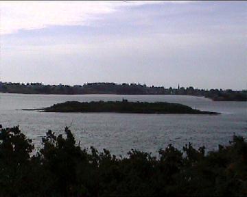
Directly in front of Gavr'inis passage mound is a
tiny island (which would have been connected in prehistory) with
a menhir on its crown. Just out of sight, and partially
submerged, are the remains of the Er-Lannic twin stone circles. Once again, whether by chance
or purpose, we are offered another variation on the mound-circle
theme that appears common to all complexes.
(More about Gavr'inis)
At the Orkneys
complex, The circles of Brodgar, Stennes and
the Maes-Howe mound, we are offered the perfect example of this union between mound
and circle. In the case of the Orkneys complex,
the sites were positioned so as to combine with the 'living' landscape
within which they were set, at the same time connecting with the cycles of
the sun and moon.
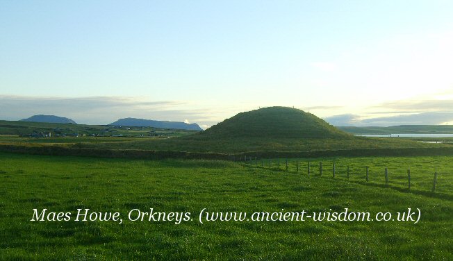
Maes Howe was positioned and orientated to
receive the setting sun for just several minutes of each year.
The whole complex is surrounded by water,
and a land-bridge connects the two stone circles together.
There are clear parallels between the Orkneys and the megalithic
concentration in the area of Wiltshire, where we find that the dominance
of the Avebury stone circle is mirrored in Brodgar, with a similar parallel between Silbury Hill and Maes Howe �
although the parallel
is in appearance alone, namely that of a conical mound symbolising the
'Hill of creation'.
However, this is not the only connection.
As early as forty years ago, another link was made between the two areas,
because both contained a type of pottery known as �Grooved Ware�. This
same pottery has since been found at other Neolithic sites and can now be
identified as originating from the same cultural source.
Avebury/Silbury: The Classic Mound/Circle.
The Avebury/Silbury complex also offers a classic
example of mound and circle. Both are the largest examples of their
kind and were clearly intended to be the most representative example
of Mound/Circle in southern Britain. Both Avebury and Silbury hill
were (arguably) surrounded by water in prehistoric times. It is
suggested that Sibury hill was deliberately built in such a way that
it was always surrounded by spring water. The western edge of
Silbury lies directly north of the eastern edge of the Avebury
Henge. Although the West-Kennet and Beckhampton Avenues appear to
direct traffic around Silbury Hill and not to it, there is no doubt
that it was a vital component of the sacred landscape.
Perhaps significantly, Michael Giles argues that
Silbury hill was built to represent an immense pregnant
earth-mother figure. He cites
references which suggest that the earth-mother figure was built into
the shape of other constructions at both the Orkneys and Malta.
(More about Silbury
Hill)
Other European complexes show the same symbolic combination of
mound and circle, although local variations apply:
At the Boyne Valley, the two structures were combined in
the same central monument,
Newgrange.
At Evora in Portugal, the twin circles of
Almendres and
the Zambujeiro passage mound would have
dominated the prehistoric landscape.
Malta has several examples of twinned temples, but on
Gozo, the temples of Ggantija stand only hundreds of yards from the
Xaghra stone circle, with its underground
burial chambers.
|
Other Similarities Between Complexes: |
There are several connections between these sites
which suggest that they performed similar functions and that a close
cultural connection existed between the builders of these apparently
separate complexes. It is through these cultural similarities that we
can perhaps begin to understand the motivation behind so many
'civil-scale'
building projects.
Spiral Art: Cross-cultural similarities.
It is
now common knowledge that the 'Temples' on Malta were designed and
constructed (at least in part), so as to capture a beam of
sunlight at specific times of the year, amplifying its importance upon
the holiest of holies deep within the structures. The temples are invariably
orientated to important parts of the solar year, such as the solstices
and equinoxes. Their internal design, whilst being more rounded,
conforms to the 'cruciform' design found in passage mounds across
western Europe, making them variants of each other (This same design
feature was noted by Sir N. Lockyer in relation to the pyramids and
temples of Egypt). In
addition, huge stone-cut
libation
bowls were found at the Tarxien, similar to those found in the passage
mounds of the Boyne Valley.
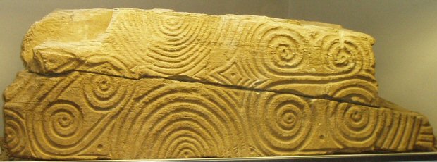
Associated with both sites is a prevalence of spiral-art,
the significance of which can
still only be guessed at.
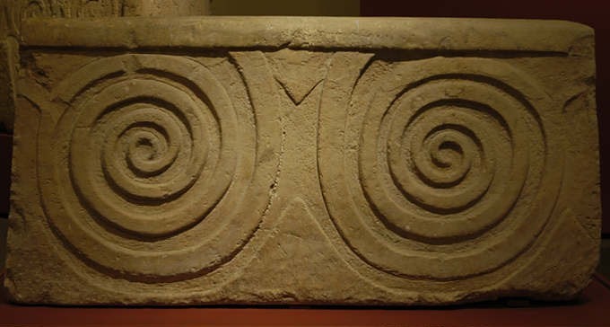
This stone is from
Bugibba temple on Malta.
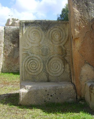
And this is one of a
pair of similar stones in the Tarxien.
Although there is no suggestion of a direct contact, there are nevertheless striking similarities between the
Maltese spiral art, and that of the Boyne Valley and Orkneys Neolithic communities as the following examples illustrate.
(More
about prehistoric Malta)
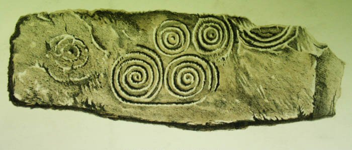
Newgrange:
The inscribed kerb-stone
that lies directly in front of the entrance to the Newgrange passage mound
has the triple spiral on the left hand side (also seen on the wall inside
the chamber). Almost identical art has been found on the Orkneys, and
variations of it can be seen throughout the ancient world.
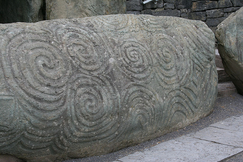
Spiral kerbstone from Newgrange.
Orkneys, Scotland: A rare piece of Neolithic art
was found on a beach by an Orkney plumber :
The 6,000-year-old relic, thought to be a fragment
from a larger piece, was left exposed by storms. Local plumber David
Barnes, who found the stone on the beach in Sandwick Bay, South
Ronaldsay, said circular markings had shown up in the late-afternoon
winter sun, drawing his attention to the piece.
Archaeologists last night heralded the discovery as a
"once-in-50-years event". But they warned that a search for other
fragments in the area would be hampered by a lack of funds.
Archaeologists compared the discovery to the Westray Stone (below), a
Neolithic carved stone discovered in 1981 during routine quarrying work.
It has been in Orkney Museum for more than 25 years but is due to be
returned to the area this week and exhibited in the new Westray Heritage
Centre in Pierowall.
The 'Westray Stone', from Pierowall
(left). The Eday Manse stone, Isle of Eday.
(right).
The Westray Stone, Orkneys.
The Westray Stone was once part of a Neolithic
chambered cairn which is thought to have been destroyed in prehistory. A
second part, and two smaller carved pieces, were found the following
spring in a dig led by Niall Sharples, of the University of Cardiff.
"The stone is perhaps from a chambered tomb and could
be as old as 5,000 or 6,000 years, and would have possibly been used as
a ceremonial, sacred object. This is art made in the same style as art
from the Newgrange stone tomb in Ireland or tombs in Brittany. It's part
of this Neolithic world linked by the Irish Sea."
The stone will now be passed to Orkney Museum and
brought to the attention of the Queen and Lord Treasurer's Remembrancer
to determine if it is a treasure trove or not. Ancient objects without
an owner are automatically property of the Crown. But Mrs Gibson added:
"An object like this becomes the property of everyone."
Ref: (http://news.scotsman.com/)
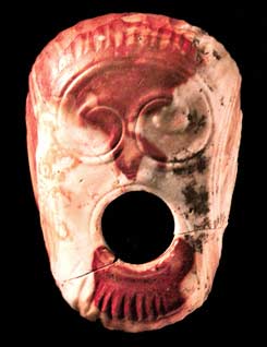
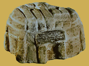
This beautiful mace-head (right), was found at
Knowth. The flint itself comes from the
Orkney islands, which are by no means
the nearest source of flint to the Boyne valley. It is one of several
clues that testify to a cultural exchange between these two important
megalithic complexes, along with the style of art, exterior and interior
similarities in design of the passage mounds (Maes
Howe) and a strong astronomical theme underlying the development of
the structures.
Having identified cultural connections existed between
complexes, we now turn to their locations. We have already noted that the
locations of the Orkneys, Avebury/Stonehenge and Evora complexes all have
an astronomical relevance, but can it be that they were chosen because of
this, and if so, are there any others?
|
Geodesy, Astronomy and the European Megaliths: |
It is impossible to hide from the fact that some of
these sites appear to show a geodetic relationship to each other, a
relationship which is strengthened by the astronomical significance of
the locations of several of these complexes. But does this mean that
they were selected because of this significance.?
It is a fact that at least
three of the complexes listed above were located at latitudes of astronomical relevance. This is not
something to be ignored as it is clear that astronomy was a primary
concern of the Neolithic builders.
Associated Astro-religious belief systems.
In order for one to
observe the celestial sky accurately, one needs to choose a site with
appropriate views of the heavens, a fact which can be seen repeated in
many of the smaller megaliths (for example, the RSC's of Scotland have
been invariably shown to be orientated towards important phases of the
lunar cycle). However, there are also locations upon this planet, at
which the celestial cycles can be measured more accurately than at
others. For example, in Egypt, it was noticed that on the 23.5�
latitude, close to the Nabta stone circle c. 4,000 BC, that there
was no shadow during the equinoxes. This simple observation can be
seen to be a natural intellectual trigger for further astronomical
knowledge, and was most likely the reason for the construction of this
particular complex at the specific location
we find it.
Extending this line of thought to Europe, we find that
there are only two latitudes at which,
in some nights of the year, you get the full moon on the zenith. The
first is
38� 33′ 28″, the
location of the Evora complex (and the
oldest astronomically orientated stone circle in Europe), while the
other latitude is 51� 10' 42" N, that of
Stonehenge. Should we consider it
a coincidence that at these very two latitudes, we find two of the
largest, earliest and most prominent stone circles on the European arena.
The idea that Stonehenge was situated astronomically (or geodetically) is not one which
sits comfortably with historians as there is good evidence for use of
the site from at least 3,500 BC (in the nearby Cursus), not forgetting the stubborn presence of the four tree-posts, which date back
to Mesolithic period 7,000 BC. However, in
favour of its deliberate and specific placement is the fact that it is at
this latitude only the sun and the moon have their maximum setting points
at 90� to each other.
Perhaps it is through these astronomical facts we this we can begin to
understand the Avebury/Silbury complex better, for the latitude of
Avebury (Which sits exactly 1/4 of a degree of latitude north of
Stonehenge), also has a mathematical significance (and one which
should also not be ignored out of hand). Avebury is located on
latitude
51� 25'
40'', which is the result of 360 divided by 7 as
seen in the following expression.
(360� / 7
= 51.428 or 51� 25' 40")
We can see the
same type of Geodesy was applied to Egyptian structures (i.e.
Karnak/Thebes), which was the sacred centre of 'upper' Egypt was built
at latitude 25� 43' N, (360 / 14), and of course
Heliopolis, which the sacred centre of 'Lower' Egypt was built on the 30th
latitude. Sacred Temples built in upper Egypt are orientated to the
solstices while those built in lower' Egypt (the pyramids), were
orientated to the equinoxes.
Karnak/Thebes (360� /
14 = or 25� 43'), Heliopolis (360� / 12 = 30)
It is perhaps also
worth noting that while the exterior angle of the Great pyramid is the
same as the latitude of Silbury Hill, the exterior angle of Silbury is
simultaneously mirrored in the latitude of the Great pyramid.
Something which can be seen to follow through to other pyramids and
latitudes..
Returning to the
Orkneys complex, we find it also has a strong astronomical
significance.
It is at the
latitude of the Orkneys that the major lunar standstills north becomes
almost circumpolar, (neither rising nor setting - with the
effect that the moon 'rolls' along the horizon). Because the
Earth�s axial tilt has changed by nearly half a degree since the
majority of the stone circles were built, this effect is no longer
accurate and the latitude today would have to be 63� north for a lunar
standstill north to be truly circumpolar
(3),
while a truly circumpolar Moon would have been visible on the Orkneys
at around 3,500 BC. Once again, we are presented with a clear reason
for the presence of this concentration of astronomically profound
Megaliths on such a desolate island group.
The sites Almendres
stone circle near Evora shares an intimate connection with Stonehenge,
in that it is located on the correct latitude so that on certain
nights over an 18.6 year cycle, the full moon can be seen on the
zenith. The close proximity of the great Zambujeiro passage mound,
which is by far the largest in Iberia, and which ranks as one of the
best in all Europe, marks the region out as having a special
significance to the Neolithic builders. The close association between
astronomy and the megalithic structures is demonstrated by connections
both at sites, and between them.
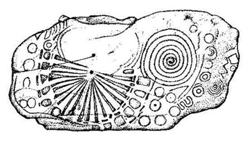
Cromleque dos
Almendres: Apart from being orientated to mark the Equinoxes, a
line from the upper edge of the circle to the nearby Menhir dos
Almendres,
follows the same path as the winter solstice sun. It is also suggested that the number of stones in the
original circle (91) may have been used to measure the number of days
between solstices (182).
Zambujeiro passage
mound - The spectacular passage mound of Zambujeiro, the largest
in all Iberia, has unfortunately suffered the ravages of time, but in
doing so, the interior structure has been revealed in a unique way,
allowing us to witness the true vastness of the structure. The passage
has a slight curve and a stone pillar slightly blocking the entrance
to the inner chamber. Both of these features are seen in other
European passage mounds where they were used to highlight the sun on
the winter solstice. The passage is orientated
approx 20�
off true East (110�).
Both of the above sites, (Almendres and
Zambujeiro) are part of an alignment which terminates at the
Xarez stone 'quadrangle', near
Monsaraz. This alignment follows the path of the spring moon. It also
raises questions about the function of such stone 'Quadrangles'.
(More about the Almendres-Xarez
alignment) (More
about Stone Quadrangles)
A Geodetic Relationship between Complexes..?
Although the
complexes appear randomly situated, several are related by complete
units of degrees of latitude.
|
Geodetic
connections between complexes. |
| Maes Howe |
58�
59' 56" N, |
3� 11' 20" E. |
Positioned due to
Lunar phenomena (See above)
|
|
|
|
|
| Newgrange |
53�
41' 40" N |
6�
28' 30" W |
Inter-visible with
Tara Hill, (Sacred heart of Ireland) |
| Tara Hill |
53� 35' N,
|
6�
36' W |
(6�
N, 3.5�
W of Carnac),
(15� N, 1.5� E of Evora) |
|
|
|
|
| Avebury/Silbury |
51� 25' 40'' N |
01� 51'
6" W |
(Latitude 360/7),
(St. Michael's Ley) |
|
|
|
|
| Carnac |
47� 35' 52" N |
03� 3' 47" W |
(9� N, 5� E of Evora),
(6�
S, 3.5�
E Tara Hill) |
|
|
|
|
| Evora |
38� 33′ 28″ N |
08� 3′ 41″ W
|
(9� S and 5� W of Carnac),
(15� S, 1.5� W of Tara Hill) |
Note: Sites that show separated by units of 1�
(accurate within 3' of a degree
or 95%)
|
Additional Sites. |
| Callanish |
58�
12' 12" N |
6� 45' 25" W |
(7� N, 4� W
G'bury), (7� N, 5� W S'henge), (5�
N, 2.5�
W B.C.Ddu) |
| Bryn Celli Ddu |
53� 12' 30" N.
|
4�
14' 20" W |
(5�
S, 2.5�
E Callanish), (2�
N, 1.5�
E G'bury) |
| Arbor Low |
53� 10' N, |
01� 46' W |
(2�
N, 1�
E G'bury), (5�
S, 5�
E Callanish), (same lat, 2.5�
E B.C.Ddu) |
| Stonehenge |
51�
10' 42" N, |
01�
49.4' W. |
(0.25� S of Avebury), (7�
S, 5� E Callanish) |
| Glastonbury |
51� 09' N |
2� 45' W |
(7� S, 4� E Callanish), (2�
S, 1.5�
W B.C.Ddu), |
|