|
Location:
Atlantic Ocean, West of the Straits of
Gibraltar. |
Grid Reference:
38� 45' N 27� 5' W
. |
 The Azores Islands:
(Portuguese Colony).
The Azores Islands:
(Portuguese Colony).
The Azores
islands are located roughly in the centre of the Atlantic ocean. They
were formed by the tectonic activity along the centre of the
Ocean floor. There are
are nine islands in total, which first appear on Genoese Portellano's
c. 1350. For a long time, reports circulated about the presence
of ancient structures and artefacts on the islands. Although
these have been consistently refuted, a new report has confirmed
the rumours to have been of substance. The pertinent question now is no
longer if, but who exactly were these prehistoric
visitors to the islands.
Article (Aug
2012): Portuguese American Journal. 'Prehistoric Rock Art
found in Azores'.
'The
president of the Portuguese Association of Archaeological
Research (APIA), Nuno Ribeiro, revealed Monday having found
rock art on the island of Terceira, supporting his belief
that human occupation of the Azores predates the arrival of
the Portuguese by many thousands of years'.
(Link
to Article)
Even after
such astonishing revelations, a research project presented in
March 2011 to the Regional Government of Azores still waits
funding. (6)
'When were the Azores
first Populated':
The recent report by the President of the
APIA has opened the floodgates to the perception of prehistoric
activity on the islands. With archaeological discoveries having
been made on most of the nine islands, there is now no doubt
that they were occupied in the past. Similarities to Greek and
Carthaginian remains are of particular interest as coins from
the same period had been previously discovered on the island of
Corvo (2)
|
The Cyrenaic and Carthaginian coins of Corvo:
'The 'Corvo Coins' refers
to a hoard of coins dating to approximately 200 BCE
that were reportedly left in the
Azores by
Carthaginians and discovered in 1749 on the
island of Corvo. The only source of information
about the find is a report published in 1778 in 'Det G�theborgska Wetenskaps och Witterhets
Samhallets Handlinger', now known as the
Publications of the
Royal Society of Sciences and Letters in Gothenburg,
by
Johan Frans Podolyn, a Portuguese-born
Swede.
According to Podolyn, in 1761 he met in Madrid the
historian and numismatist
Enrique Fl�rez who gave him 9 coins from
Carthage (2 gold and 5 bronze) and 2 from
Cyrene (bronze), which Flores said were from a
hoard discovered in 1749 in a black pot or vase
after being washed out of the foundations of a
building by a storm'
(3)
(Other
Carthaginian Coins Found in the Americas) (Report
by Dr Mark A. McMenamin)
|
The Statue of a Horseman:
In the
year 1567, Damien de Goes, biographer of
the sixteenth-century Portuguese kings, reported that a stone statue
of a bareheaded man clothed in a Moorish cape and seated on a horse
had been found at Corvo. His left arm rested on the horse's mane,
while his right arm stretched straight out with the index finger
pointing to the west. King Emmanuel of Portugal (1495-1521) sent for
the statue, but those in charge of the project carelessly broke it.
Nonetheless, the heads of the man and horse, and the right arm with
the pointed finger are said to have been brought to the king's
palace for display. De Goes added that in
1529 it was noted that the base on which the statue had stood was
inscribed. Wax impressions of the inscriptions were made, but could
not be read as the letters were very worn
and "almost without form."
In
1628, Manoel de Faria y Sousa, another Portuguese historian,
repeated de Goes's tale. It might well have died there, but
in 1778 Johan Podolyn added to this account a description of the statue of
Corvo, citing Faria y Sousa as his source, and discussed the
possibility that Carthaginian sailors discovered Corvo,
settled there, erected the statue, and left the coins. He
then ventured the opinion that these colonists undertook an
expedition "to the west," the statue indicating with its
pointed finger where they had gone.
Ibn Khordadbey (mid-ninth century) said that at the
outermost end of the world, off the Spanish coast, there was
a warning monument: a bronze horseman who, with his
outstretched arm, indicates that beyond here there is no
clear way, and anyone who ventures farther will be swallowed
up. The myth of a warning statue found its way from Arab
geographers to medieval European cartographers, and in 1367
made its clearest appearance on a map created by the Italian
Pizigano brothers. At the edge of their map, just about
where the Azores actually are, is a figure with an
outstretched arm, and, next to it, a medallion with an
inscription on it. The inscription is in part
unintelligible, but the message is clear: there is a
statue here and navigation beyond it is impossible.
(7)
The local
stories of ancient discoveries such as the mysterious equestrian
statue, the Carthaginian coins, or the strange inscriptions
found along the coast of Quatro Ribeiras (on Terceira) have all
remained unsubstantiated until now.
Columbus and the
Azores:
It was famously recorded that
Columbus and his wife moved to the island of Santo Maria. Here
he learned that strange items had been washed upon the shore of
local beaches including carved pieces of wood unlike any in
Europe. There were huge hollowed out carved pine-tree trunks,
which he would later discover were made by Indians and called
�canoes.� Most significant, two bodies of dead men washed up on
shore. Their features differed from those of the known races,
the known world of Columbus�s day extending on the north to
Iceland and Scandinavia, south to a cape 100 miles south of the
Equator, to the east as far as China and Japan, and to the west
as far as the Azores. (4)
According to Bartolom� de
las Casas, the two dead bodies that looked like those of Indians
were found on the Portuguese Flores Island in the Azores. He
said he found that fact in Columbus' notes, and it was one
reason why Columbus presumed that India was on the other side of
the ocean. (5)
The event was recounted by
Alexander Von Humboldt in 1803:
"Whilst the art of
navigation was yet in its infancy, the Gulf-stream suggested
to the mind of Christopher Columbus certain indications of
the existence of western regions. Two corpses, the features
of which indicated a race of unknown men, were cast ashore
on the Azores, towards the end of the 15th century. Nearly
at the same period, the brother-in-law of Columbus, Peter
Correa, governor of Porto Santo, found on the strand of that
island pieces of bamboo of extraordinary size, brought
thither by the western currents. The dead bodies and the
bamboos attracted the attention of the Genoese navigator,
who conjectured that both came from a continent situated
towards the west. We now know that in the torrid zone the
trade-winds and the current of the tropics are in opposition
to every motion of the waves in the direction of the earth's
rotation."
(Pre-Columbian
Americas Homepage)
Cart-ruts on the
Azores:
The presence of
cart-ruts on the Azores is one of the most unexpected facts to
present itself in the search for the first settlers on the Azores.
These enigmatic features are found in large numbers around the
Mediterranean basin, in Italy, Portugal, France, and most famously
on Malta. The Portuguese cart-ruts are pre-Christian, as are those
on Malta. As we have no record of their being made since the
'official' discovery of the Azores, we must assume that these were
made by a people prior to the Portuguese.
There are three
physical explanations for the existence of cart-ruts. They are:
1). They were
carved into the rock to facilitate the passing of some form of
vehicles.
2). They were
worn naturally by the passing of numerous vehicles over a long
period of time.
3). They were
made by the passing of a single vehicle over a soft substrate
which has since solidified.
All of these
possibilities pose problems in the case of the Azores: The first
alternative requires a large supply of manpower, lots of time and a
considerable motivation. The second requires considerably more time
and an immense amount of traffic (in order to carve such deep tracks
into rock). The third option is entirely refuted by geologists. As
we have no record of such practices by the Carthaginians or Greeks,
we probably need to look elsewhere to find the origin of these most
peculiar geological features. The Maltese cart-ruts have now shown
to have an association with the temple building period c. 3,000 BC.
Not only are the stones used to build the temples the same
dimensions as the 'gauge' of the tracks, but they are found close to
the temples themselves. Again, none of these facts appear to be
relevant on the Azores so for now, at least, the very existence of
what is essentially a 'prehistoric' feature is one of the islands
most fascinating mysteries.
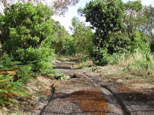
Cart-ruts on
Terceira, Azores.
(Photo Credits: Antonieta Costa,
Antonio
Ara�jo)
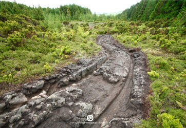
Cart-ruts running
into the sea, as on Malta.
(Cart-Ruts Homepage)
Hypogea:
The presence of
'Dozens of Hypogea'
(1) on Terceira and Corvo,
along with indications of 'Additional Hypogea sites on the
island of Flores' is a strong indication that the islands
were home to a considerable population of people, more than one would expect
from a single, random encounter with the island. The wide
distribution and presence on more than one island combined with
their frequency supports the idea that the islands were peopled
by a deliberate act of extensive population.
(Photo Credits: Antonieta Costa)
The Hypogea are
said to be pre-Christian, and according to the APIA president: 'These
kinds of monuments have parallels in the Mediterranean world,
and the Greek and Carthaginian cultures'
(1)
'Archaeologists
from the Portuguese Association of Archaeological Research
(APIA) believe to have found in the Azores a significant
number of Carthaginian temples from the fourth century BC,
dedicated to the goddess Tanit' ... 'More than five hypogea
type monuments and at least three 'sanctuaries' were found'
... 'The temples carved inside the hypogea structures are
large and very well preserved and were drawn almost in a
triangular shape' ... 'There are chairs carved into the
rock, a ceremonial tank,, sinks linked to conduits to
collect fresh water associated with ritual libations,
probably for sacrificial purposes'.
(2)
The
implications of a deliberate emigration of people to the centre
of the Atlantic ocean in prehistoric times is probably the very
reason why the idea has been rejected for so long. Such acts of
population are not simple leaps of faith, they have to be
planned and executed with a great presence of mind, involving a
knowledge of navigation, the location of the islands
(longitude/latitude?), sea-going vessels, a
large number of people, skills, stocks, supplies,
tools... etc etc.
Photo Gallery: The Azores.
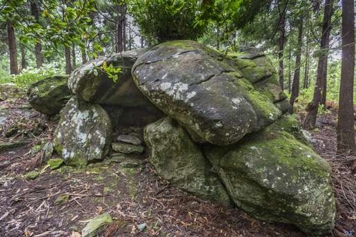
Megalithic construction on
Terceira.
(Photo Credits: Antonieta Costa)
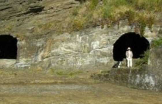
Rock-cut Hypogea
on Mont Brazil, Terceira.
(Other Prehistoric Underground Structures)
(Pre-Columbian
Contact with the Americas)
(Prehistoric Portugal Homepage)
(Other Portuguese Locations)
(Cart-Ruts homepage)
|