|
 The Pre-Columbian America's:
The 'discovery' of the Americas in
1492 signalled one of history's most profound cultural decimations.
Although today, the savagery of such
conquest might appear alien to us, as we sift through the
fragmentary remains of pre-Columbian history, we reveal that it is
still only ourselves we have to fear.
Quick Links:
(List and
Description of Featured American Sites )
When were the America's
First Colonised.
There is no question that the Americas
were populated for a long time before Columbus' arrival in 1492. The
focus of debate today is centred on suggestions that the Americas
had been colonised by people from what is generically termed the
'old-world'.
Pre-Clovis Colonisation?
Two Mexican sites continue years after their
excavation to be proposed as valid pre-Clovis sites. At Tlapacoya,
Mexico, presumed hearths associated with animal bone middens were dated
to 24,000 � 4000 and 21,700 � 500 years B. P. (Lorenzo and Mirambell
1999:488-489). Lorenzo and Mirambell (1999:489) recently concluded that
"these dates provide clear evidence of human activity at the site about
22,000 years ago." At the site a prismatic obsidian blade found under a
tree trunk dated to 23,950 � 950 years B. P. was obsidian hydration
dated to between 21,250 and 25,000 years B. P. (Lorenzo and Mirambell
1999:489).
Between 1977 and 1984, at El Cedral,
San Luis Potosi, Mexico, excavation of a spring with an abundance of
faunal remains produced, from a stratum dated to 33,300 � 2700 years B.P.,
a circular scraper manufactured from microcrystalline quartz by direct
percussion (Lorenzo and Mirambell 1999:491). A limestone core was
recovered from a stratum dated at 15,000 years B.P., and the nearest
identified limestone source is 5 km distant (Lorenzo and Mirambell
1999:491). A hearth containing a charcoal lens dated to 31,850 � 1600
years B.P. and ringed with proboscibian tarsi "leave no room for doubt
that it is the product of human activity," according to Lorenzo and
Mirambell (1999:492). Three other roughly contemporaneous hearths dated
to between 26,000 and 28,000 years B.P., while the two hearths producing
the sites limiting dates dated to 37,694 � 1963 and 21,468 � 458 years
B.P. (Lorenzo and Mirambell 1999:492). The seven superimposed hearths
varied in size from 60 to 170 cm in diameter and contained many small
fragments of burned bone (Lorenzo and Mirambell 1999:493).
(18)
Monte Verde, Chile:
Meltzer wrote (1995:21), "The Monte Verde site in Chile is the most
viable pre-Clovis candidate, although for now neither it nor any
other site resolves when or by which route humans first came to the
Americas." According to Adovasio (the excavator of Meadowcroft) and
Pedler (1997:573), Monte Verde, with its exceptionally well
preserved organic material and artefacts radiocarbon dated to
between 12,500 and 13,000 years B.P. "may prove to be the seminal
archaeological site that will finally prevail over the Clovis-first
model." Monte Verde was excavated from 1977 to 1985 and analyzed by
more than 70 collaborating researchers. Monte Verde contains four
discrete zones of buried cultural material and two components. The
first, or basal, component, Monte Verde I, produced a radiocarbon
determination of 33,370 �530 years B.P., associated with stones not
yet shown to be artifactual (Roosevelt, et. al. 1996:363). The
second component, Monte Verde II, has produced more than 30
radiocarbon determinations averaging 12,500 to 13,000 years B.P. (Adovasio
and Pedler 1997:574). Because of the debate over the dating of the
Monte Verde site, a group of archaeological specialists visited the
site to assess its validity. They had to examine the artifacts,
study the site�s stratigraphy and evaluate the reliability and
internal consistency of the radiocarbon determinations. Their
on-site visit focused on depositional circumstances, confirmation of
stratigraphy, validation of depositional context, anthropogenic
reality of alleged living structures, and potential sources of
carbon contamination at or near the site (Adovasio and Pedler
1997:577). All the specialists agreed that there were indisputable
human artifacts in a primary depositional context mantled by a peat
layer and without indication of materials deriving from later
depositional horizons at the site (Adovasio and Pedler 1997:578).
The specialists reviewed the Monte Verde collections, geology,
stratigraphy and chronology before reaching a consensus that Monte
Verde "is a bona fide site" (Bonnichsen and Schneider 1999:497).
(18)
Article: NewScientist.com (Apr. 2013)
'A team claims to have found 22,000-year-old stone tools at a site in Brazil,
though other archaeologists are disputing the claim. Christelle Lahaye of Michel
de Montaigne Bordeaux 3 University in France and colleagues excavated a rock
shelter in north-east Brazil and found 113 stone tools. The team dated the
sediments in which the tools were buried using a technique that determines when
the sediments were last exposed to light. Some tools were buried 22,000 years
ago � thousands of years earlier than any known human colonisation of the
Americas'.
(Link
to Full Article)
Article:
ScienceDaily (May 23, 2011)
'South
America's Oldest Textiles Identified With Carbon Dating'.
'Textiles and rope
fragments found in a Peruvian cave have been dated to around 12,000 years
ago, making them the oldest textiles ever found in South America, according
to a report in the April issue of
Current Anthropology'
Article: Science Daily (Apr. 3, 2008)
'DNA from dried human excrement recovered from Oregon's Paisley Caves is the
oldest found yet in the New World -- dating to 14,300 years ago, some 1,200
years before Clovis culture -- and provides genetic ties to Siberia or Asia,
according to an international team of 13 scientists'.
(5)
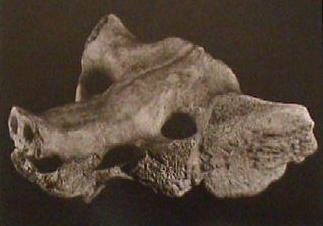
The now fossilised, worked bone in the photo
(above), was found nearly 40ft deep in upper Pleistocene deposits dating
from about 10,000 - 8,000 BC, at Tequixquiax, in the north of the valley
of Mexico. Height 6 inches (15.4cm). (Present location: Museo Nacional
de Antropologia, Mexico).
|
Pre-Columbian American Cultures: |
The North American Indians.
Numerous Palaeo-Indian cultures occupied North
America, from around the Great Plains and Great Lakes of the modern United
States of America and Canada, as well as adjacent areas to the West and
Southwest. According to the oral histories of many of the indigenous peoples
of the Americas, they had been living on this continent since their genesis,
as described by a wide range of traditional creation stories. However,
genetic and linguistic data connect the indigenous people of this continent
with ancient northeast Asians. Archaeological and linguistic data has also
now enabled scholars to determine some of the migrations within the
Americas.
Much has been written about the American
Indian lifestyle, but the portrayal of Indians as war-painted savages still
prevails in literature and on the screen. Sadly, many of the most important
aspects of Indian lifestyle have been washed over in the course of providing
this more commercially popular (and easier on the conscience) image of them.
However, it is these very aspects of their lifestyle that are now recognised
to be of such value in the way we perceive our relationship with the world
today.
Estimates
on the American Indian population before European contact range
from between 2 and 18 million. By
1890, only 250,000 native Americans remained.
(1) The total death
toll has been estimated at around 100 million American Indians
from the time of Columbus' arrival to the end of the Indian
Wars 400 years later.
(More about the North American Indians)
A Summary of
the better known Pre-Columbian Mesoamerican cultures:
One of the most significant realisations from Meso-American archaeology is that several well-formed civilisations appear to have
risen to greatness, only to disappear seemingly overnight from historical record.
This same cycle of the 'rise-and-fall' of civilisations can be seen to be repeated around the ancient world,
making it one of the most pertinent questions of prehistory, and one which
perhaps deserves more debate in this time of global angst.
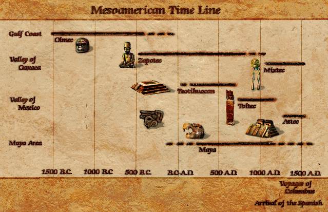
The Olmecs:
(c. 1,500 BC - 400 BC) -
The Olmecs were one of the first proper civilisations in
Mesoamerica. Their culture is epitomised by extraordinarily lifelike and
dynamic statues of people and several large carved Stone-heads. If
the Olmecs are to be in any way gauged on their art, they appear to
have been an almost multi-cultural society, with several genotypes
present, including Oriental, Negroid and European (bearded). They
are also the first culture to use the now-famed 'long-count', later
adopted by the Mayans. The Long-count has a start date of 3,113 BC.
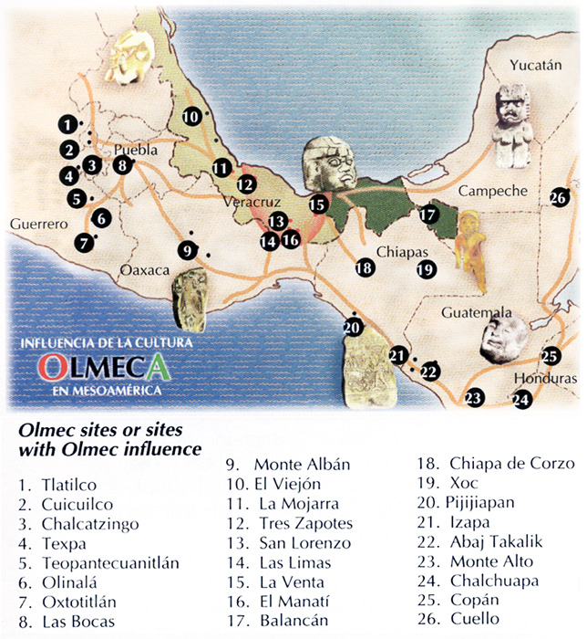
(Image Credits:http://www.latinamericanstudies.org)
(Tres
Zapotes) (La Venta)
(San Lorenzo) (Monte
Alban) (Cuicuilco)
(The
Carved Olmec Stone-Heads)
(Olmecs
Homepage)
Teotihuacan civilization:
(c. 300 BC - 650 AD) - The
decline of the Olmec resulted in a power vacuum in
Mexico. Emerging from that vacuum was Teotihuacan, first
settled in 300 BC. By 150 AD, Teotihuacan had risen to
become the first true metropolis of what is now called
North America. Teotihuacan established a new economic
and political order never before seen in Mexico. Its
influence stretched across Mexico into Central America,
founding new dynasties in the Maya cities of Tikal,
Copan, and Kaminaljuy�. Teotihuacan's influence over the
Maya civilization cannot be understated: it transformed
political power, artistic depictions, and the nature of
economics. Within the city of Teotihuacan was a diverse
and cosmopolitan population. Most of the regional
ethnicities of Mexico were represented in the city, such
as Zapotecs from the Oaxaca region. They lived in
apartment communities where they worked their trades and
contributed to the city's economic and cultural prowess.
By 500 AD, Teotihuacan had become the largest city in
the world. Teotihuacan's economic pull impacted areas in
northern Mexico as well. It was a city whose monumental
architecture reflected a monumental new era in Mexican
civilization, declining in political power about 650
AD�but lasting in cultural influence for the better part
of a millennium, to around 950 AD
(Teotihuac�n)
The Zapotecs:
(c. 600 BC - 700 AD) -
The Zapotec civilisation flourished in the Valley of Oaxaca of
southern Mesoamerica. Archaeological evidence shows their culture
goes back at least 2,500 years. They left archaeological evidence at
the ancient city of Monte Alb�n in the form of buildings, ball
courts, magnificent tombs and grave goods including finely worked
gold jewellery. They had a form of writing which is considered
(along with another possible Olmec script), to be the predecessor of
Mayan, Mixtec and Aztec writing. Monte Alb�n was one of the first
major cities in Mesoamerica and the centre of a Zapotec state that
dominated much of what is now the Mexican state of Oaxaca.
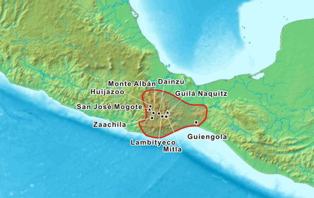
(More
about Monte Alb�n)
The Mayans:
(c. 2,000 BC - Present). There is some debate over when the Mayan
Civilisation began. The Mayan chronology is now divided into three
periods of time; The Pre-Classic (c. 2000 BC - 250 AD), from which
we still have the remains of the largest pyramid in the world 'La
Danta', at the 'Cradle of Mayan Civilisation' -
El Mirador, Guatemala; The
Classic period (c. 250 - 900 AD) which can be considered as the
'Temple building phase', and the Post-Classic (900 AD - Spanish
conquest 1492). The Mayan culture is noted for having the only full
written language in Pre-Columbian America., as well as being highly
skilled in astronomy, mathematics, and for their uniquely
imaginative art. The Mayan peoples never disappeared, and today
their descendants still form sizeable populations in the Mayan
lowlands, living with a mixture of Pre and Post Columbian ideas.
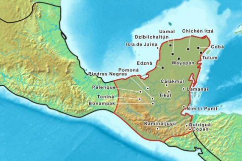
(Chitzen
Itza) (Palenque)
(El Mirador)
(Mexico
Homepage)
Incas: (c.
1,200 AD - 1,520 AD) The Incas were the largest and the last
of a complex of Andean civilisations formed primarily from the
ancient Tiahuanacan and Peruvian cultures. The earliest traces of
cultures in Peru are found in the Caral-Supe culture on the northern
coast, predating the Olmecs by at least a millennium (c. 3,500 BC).
Inca tradition spoke of the founding Inca male and female coming to
Cuzco
from the 'Island of the Sun' on Lake Titicaca, nearby.
(4)Other
important Peruvian cultures include the Chavin, Nazca, Moche, and
Tiahuanacan. The Inca culture is typified by its cyclopean masonry
and networks of roads. Their king was considered the 'Child of the
Sun'.
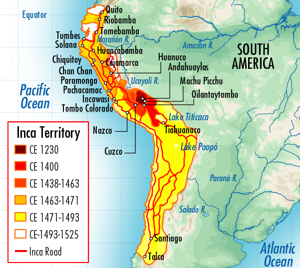
(Cuzco)
(Sacsayhuaman) (Machu
Pichu) (Chavin Du
Huantar) (Ollantaytambo)
(Nazca)
(Prehistoric
Peru Homepage)
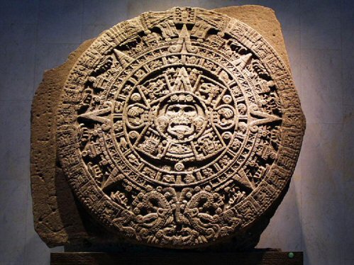
Aztecs:
(c.1,400 AD - 1,520 AD) The world "Aztec" is the Nahuatl word
for "people from Aztlan", (14)
a mythological place for the Nahuatl-speaking culture
of the time. The Aztec empire arose only a hundred years before
Cortez arrived and decimated it. The Aztecs borrowed much of their
culture from the Toltecs, who in turn took influence from the
Teotihuanacans, all located in the Valley of Mexico. The ruins of
the capital city of the Aztecs, Tenochtitlan, are located in Mexico
city. The Aztec empire is marked for the practice of human sacrifice
(as were the Mayans). When Cortez arrived, he found a culture
saturated by their own blood, who believed they had to sacrifice to
sustain the path to death.
(Teotihuacan)
(Tula) (Tenochtitlan)
|
Featured Pre-Columbian Locations: |
| |
|
 |
- Atacama:
(Giant and Newly Discovered Complex)
The Atacama Desert in Chile is officially the driest place
on Earth. Ironic then that a recent discovery has revealed
the presence of a vast complex of structures sitting right
beside the largest petroglyph in the world (The Atacama
Giant), and lying buried beneath what can only be very
ancient flood events. (More
about the Atacama Desert) |
| |
|
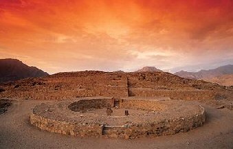 Caral-Supe
Complex. Caral-Supe
Complex.
At 2,600 BC,
this is the oldest centre of civilisation in the Americas. A
quipu (the knot system used in Andean civilizations to record
information) found on the site testifies to the development and
complexity of Caral society. The city�s plan and some of its
components, including pyramidal structures and residence of the
elite, show clear evidence of ceremonial functions and
monumental architecture, including six large pyramidal
structures.
(More
about the Caral Pyramid Complex)
| |
|
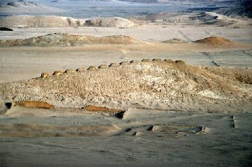 |
- Chankillo:
(Landscape Observatory)
The Thirteen Towers of Chankillo run north to south along a
low ridge within a fourth-century B.C. ceremonial complex in
north coastal Peru. They formed an
artificial toothed horizon that spanned the annual rising
and setting arcs of the Sun. At present, the
culture that made them has not been named. (More
about the Chankillo Observatory) |
| |
|
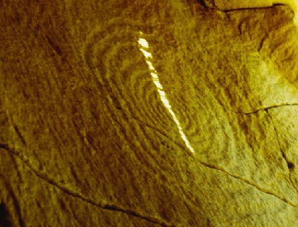
The
Chaco canyon 'Sun-dagger'
In what is now the state of New Mexico
in an area known as Chaco Canyon are the remains of an elaborate
development of the Anasazi people who lived in the region from about 500
to 1300 AD. Some 120 meters (400 feet) above the canyon floor near the
top of an outcropping known as Fajada Butte, three slabs of sandstone
were placed against a rock wall creating a shaded space. Carved into
this shaded wall are two spiral petroglyphs, one large and one small.
Sunlight passes over them at various times throughout the year as it
streams through chinks between the sandstone, but it was not until the
1970s that their true purpose was literally illumined.
(More
about the Chaco-canyon sun-dagger)
| |
|
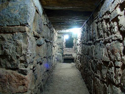 |
- Chavin du Huantar:
(Capital of the
Chavin Culture)
Chavin du Huantar, is an unusual complex of
steeply walled platforms, honeycombed with stone-lined passages surrounding
a sunken plaza. It is unique amongst Pre-Columbian temple groups. The
principle edifice, called 'The Castillo' is faced with cut-stone blocks in
courses of varying widths. Inside the core are at least three irregular
storeys of stone-lined galleries, chambers and ventilating shafts.
(More about Chavin du
Huantar) |
| |
|
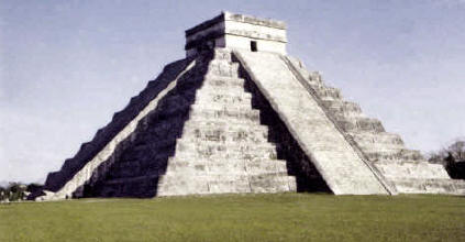 Chichen
Itza - Chichen
Itza - (Abandoned Mayan city).
The stepped pyramid-temple records the
equinoxes in a unique way. The sun creates a shadow of a huge 'snake' to ascend
the steps in spring, and descend again in autumn
(2). Whether or not this was a deliberate
design feature is speculative, but other astronomical features at the site
certainly lend weight to the idea that it was intentional.
Each step corresponds to a day, each platform
to a Mayan month. The temple is erected above the 365 steps.
(17)
(More about Chichen Itza)
| |
|
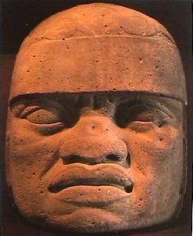 |
- The Olmecs - The First Multicultural
Society.?
It was in 1938 that Dr. Mathew Stirling uncovered
the first Olmec head which was made from a single piece of basalt rock
resting on a prepared foundation of un-worked slabs of stone. He said of it:
'...The
features are bold and it is amazingly negroid in character'.
(3)
(More about the Olmecs) |
| |
|
Machu Pichu
-
(Mountain Citadel)
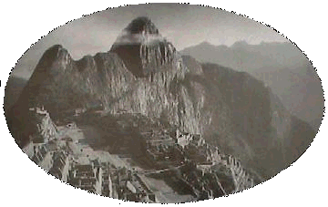 This
Pre-Columbian Inca mountain citadel was only rediscovered in 1911. It
shows several strong indications of astronomical observation.
The structures are built from white
granite, with blocks reaching up to 3.7 metres in length. This
Pre-Columbian Inca mountain citadel was only rediscovered in 1911. It
shows several strong indications of astronomical observation.
The structures are built from white
granite, with blocks reaching up to 3.7 metres in length.
Location of the "The Hitching Point of the Sun" because it was believed
to hold the sun in its place along its annual path in the sky. At
midday on March 21 and September 21, the equinoxes, the sun stands almost
above the pillar�casting no shadow at all.
Skeletal remains show a 10:1 ratio of females to males.
(12)
(More about Machu Pichu)
| |
|
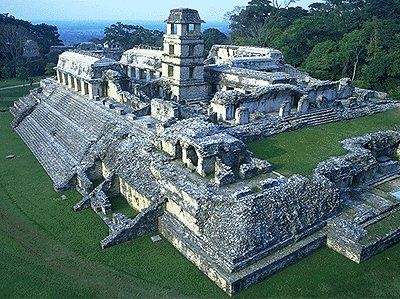 |
-
Palenque:
(Mayan Pyramid Complex)
' The
entire city of Palenque was solely a priestly centre, a place of pilgrimage'.(8) The city is laid out
in the shape of an amphitheatre, with a central pyramid. The city was
deserted in the 8th century AD, along with several other Mayan centres. Archaeologists estimate that only 5% of the total city has been uncovered.
(More about Palenque) |
| |
|
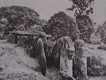 San
Agustin, Columbia:
(Megaliths and Hypogea).
The San Agustin archaeological park in Colombia includes a
wide variety of stone sculptures (Megaliths), mostly carved between AD 100 and
1200. In the park are an amazing array of separate stone sculptures, in the
shapes of animals and warriors and human faces, some mythical, some realistic.
They are carved out of volcanic rock - some are over 4 meters tall and weigh
several tons. The site, excavated by K. Th. Preuss during the 1940s, has been
declared a World Heritage Site.
( More
about San Agustin)
| |
|
 |
|
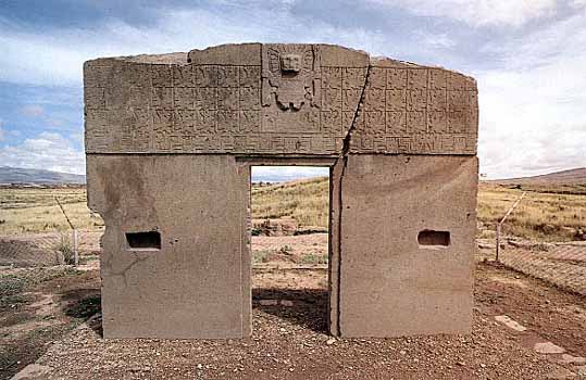
The city was the administrative and religious
heart of a pre-Incan civilisation that began in the year 237 BC
and endured for over 1,400 years. During its peak the Tiahuanacan Empire covered nearly all of Bolivia, Northern
Chile and Southern Peru, ruling over more than three million
subjects.
(9)
(More about
Tiahuanaco)
|
| |
|
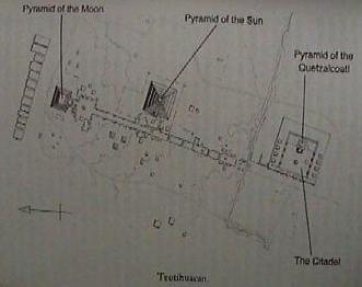
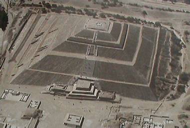 Teotihuac�n
-
(The 'City of the Gods'). Teotihuac�n
-
(The 'City of the Gods').
It was
suspected by Stansbury Hagar, that the city had been built as a 'map of heaven'.
During the 1960's and 1970's a comprehensive mathematical survey was carried out
by Hugh Harleston Jr who determined that the principle structures line up along
the street of the dead (and beyond), and that the city was a precise scale model
of the solar system. (21)
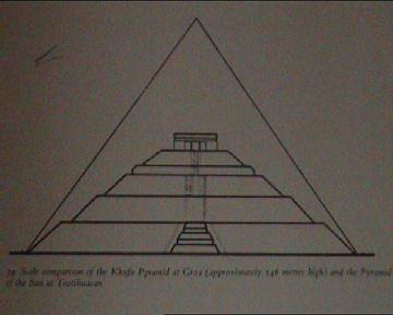
The Pyramid of the sun
(Left), has the same base dimensions and half the height of the great pyramid
in Egypt.
(More about Teotihuacan)
|