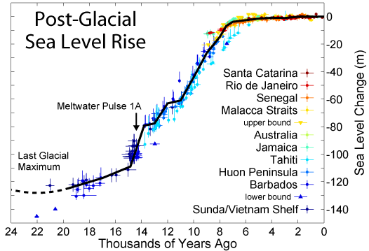
Following the end of the
last ice-age the world experienced a period of flood events, which raised
the coastline around the world by several metres, flooding all the existing
coastal cultures of the time. This natural process has occurred again and
again over history, with the sea-level mostly lower than it is today through
the long periods of Ice-age. The contours of these
'Ice-age' coast-lines are
easy to determine with contour maps which show what's commonly called the
'continental shelf'.
In fact, with computer simulation, it is now becoming possible to estimate the
age of underwater discoveries reasonably accurately through their relative depths underwater. While it is accepted
that this science is still in its infancy, the implications of certain
underwater discoveries are forcing historians to reconsider the
recent path of human evolution.
The strong
traditions and myths surrounding water have given it an
association with the sacred. The Sumerian 'Epic of Creation'
describes the Fish-God Eana coming from the water 'after
the deluge' to bring knowledge to the people. A similar myth
exists in south American with Quetzalcoatl, while in the bible,
we are told that God sent a flood to destroy mankind for its
sins. Perhaps this is why water has also adopted such a strong
association with the afterlife. In many myths, the 'Primal
Mound' is mentioned, rising from the watery deep. This
particular set of myths is reflected in the association between
pyramids and water, as seen in many of the largest pyramid
complexes in the ancient world.
It
was announced, following the Boxing-day Tsunami of 2004 that the remains
of an ancient city was uncovered close to the Mamallapuram temple in
Tamil Nadu, India.
UK News report - Quote:
'The remains, which include two
granite lions were discovered after the coastline had receded by a
fisherman who survived the tsunami by clinging to the arch of the
shore temple. Scientists from the Archaeological Survey of India are
examining the relics close to the 7th century beachfront temple and
are continuing an underwater search that started in 2002 for further
remnants of the submerged port city. Legend has it that a large city
which once stood on the site was so beautiful that jealous gods sent a
flood to swallow it'.
(The Guardian. 02.04.2005)
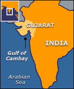
The Gulf
of Cambay cities: Update.
Work in peripheral land
areas of the Gulf of Cambay like Kathana, Lotal and Motibaur gave
evidences of major earthquakes in the Cambay areas in the following period
(1) 2780 �
150 years BP, (2) 3983 � 150 BP and (3) 7540 � 130 BP. Herein lies the
evidence of the end of the Gulf of Cambay civilization.
In the old major event at
about 7,600 BC, the southern metropolis appear to have been thrown down by
faulting and the nearby sea appear to have inundated it. Because of this
the people appear to have proceeded north in the elevation higher than the
sea level and established the 2nd or northern metropolis.
This also got affected by
faulting due to earth quakes around 4,000 BP and destroyed by the 2780 �
150 BP earthquake, by down-throwing the metropolis with the sea transgressed the area
to completely submerging it.
The site has yielded
artefacts dated at 9,500 BP. (7,500 BC)
The vast city - which is five miles long and two miles wide
- is believed to predate the oldest known remains in the
subcontinent by more than 5,000 years.
The site was discovered by
chance last year by oceanographers from India's National
Institute of Ocean Technology conducting a survey of
pollution.
Using sidescan sonar - which sends a beam of sound waves
down to the bottom of the ocean they identified huge
geometrical structures at a depth of 120ft.
Debris recovered from the site - including construction
material, pottery, sections of walls, beads, sculpture and
human bones and teeth has been carbon dated and found to be
nearly 9,500 years old.
Marine archaeologists have used a technique known as
sub-bottom profiling to show that the buildings remains stand
on enormous foundations.
Chronological problem
This, Mr Hancock told BBC News Online, could have massive
repercussions for our view of the ancient world.
"There's a huge chronological problem in this discovery. It
means that the whole model of the origins of civilisation with
which archaeologists have been working will have to be remade
from scratch," he said.
However, archaeologist Justin Morris from the British
Museum said more work would need to be undertaken before the
site could be categorically said to belong to a 9,000 year old
civilisation.
"Culturally speaking, in that part of the world there were
no civilisations prior to about 2,500 BC. What's happening
before then mainly consisted of small, village settlements,"
he told BBC News Online.
Dr Morris added that artefacts from the site would need to
be very carefully analysed, and pointed out that the C14
carbon dating process is not without its error margins.
It is believed that the area was submerged as ice caps
melted at the end of the last ice age 9-10,000 years ago
Although the first signs of a significant find came eight
months ago, exploring the area has been extremely difficult
because the remains lie in highly treacherous waters, with
strong currents and rip tides.
The Indian Minister for Human Resources and ocean
development said a group had been formed to oversee further
studies in the area.
"We have to find out what happened then ... where and how
this civilisation vanished," he said.
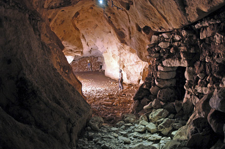
A labyrinth filled with stone temples and
pyramids in 14 caves�some underwater�have been uncovered on Mexico's
Yucat�n Peninsula, archaeologists announced in Aug 2008.
According to Maya myth, the souls
of the dead had to follow a dog with night vision on a horrific and
watery path and endure myriad challenges before they could rest in
the afterlife.
In one of the recently found
caves, researchers discovered a nearly 300-foot (90-meter) concrete
road that ends at a column standing in front of a body of water.
"We have this pattern now of
finding temples close to the water�or under the water, in this most
recent case," said Guillermo de Anda, lead investigator at the
research sites.
Saturno said the discovery of the
temples underwater indicates the significant effort the Maya put
into creating these portals. In addition to plunging deep into
the forest to reach the cave openings, Maya builders would have had
to hold their breath and dive underwater to build some of the
shrines and pyramids.
Other Maya underworld entrances
have been discovered in jungles and above-ground caves in northern
Guatemala Belize. These
Pre-Columbian discoveries testify to the strong link between water
and the underworld. There have been several recent discoveries of
cave systems with temples built underwater in the caves themselves.
This has greatly enhanced our understanding of the Mayan concept of
the underworld. In 2008 in one cave, researchers discovered a nearly
300-foot (90-meter) road that led down to a column standing in front
of a body of water. "We have this pattern now of finding temples
close to the water�or under the water"
(11).
The Chitzen Itza complex was built beside two water filled
'cenotes', now considered the very reason for the location of the
temple complex itself. The numerous discoveries of worship,
sacrifice, blessings and incense at cenotes leave little doubt as to
their having been considered as entrances to the underworld
(12).
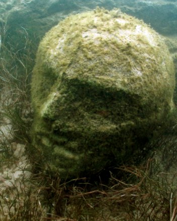
This recently
discovered stone-head was found in the waters of Lake Traful, in
Patagonia, Argentina. The Lake is the starting point of the
Traful River that empties into the Nahuel Huapi Lake. At Present
nothing more is known about it.
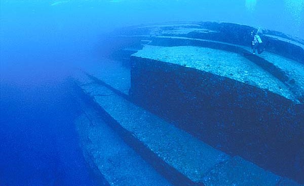
Found near the south shore of Okinawa, Japan in
1995, these fantastic underwater structures were at first argued to have been
fashioned by nature.
'The sunken buildings are known to
cover the ocean bottom (although not continuously) from the small island of
Yonaguni in the southwest to Okinawa and its neighbouring islands, Kerama
and Aguni, some 311 miles. If, after all, ongoing exploration here does
indeed reveal more structures linking Yonaguni with Okinawa, the individual
sites may be separate components of a huge city lying at the bottom of the
Pacific. The single largest structure so far discovered lies near the
eastern shore of Yonaguni at 100 feet down. It is approximately 240 feet
long, 90 feet across and 45 feet high'. (2)
'The 'Yonagumi monument
is over 50m long in an east-west direction and over 30m wide in a
north-south direction. The top of the structure lies about 5m below sea
level, whereas the base is approximately 25m below the surface'
(3)
Archaeologists are uncovering a huge prehistoric "lost
country" hidden below the North Sea.
Extract
fromBBC News education by
Sean Coughlan:
(4)
This lost landscape, where hunter-gatherer
communities once lived, was swallowed by rising water levels at the end
of the last ice age.
University of Birmingham researchers are heralding
"stunning" findings as they map the "best-preserved prehistoric
landscape in Europe".
This large plain disappeared below the water more
than 8,000 years ago.
The Birmingham researchers have been using oil
exploration technology to build a map of the once-inhabited area that
now lies below the North Sea - stretching from the east coast of Britain
up to the Shetland Islands and across to Scandinavia.
"It's like finding another country," says
Professor Vince Gaffney, chair in Landscape Archaeology and Geomatics.
It also serves as a warning for the scale of impact that climate change
can cause, he says.
Human communities would have lost their homelands
as the rising water began to encroach upon the wide, low-lying plains.
"At times this change would have been insidious
and slow - but at times, it could have been terrifyingly fast. It would
have been very traumatic for these people," he says.
"It would be a mistake to think that these people
were unsophisticated or without culture... they would have had names for
the rivers and hills and spiritual associations - it would have been a
catastrophic loss," says Professor Gaffney.
As the temperature rose and glaciers retreated and
water levels rose, the inhabitants would have been pushed off their
hunting grounds and forced towards higher land - including to what is
now modern-day Britain.
"In 10,000 BC, hunter-gatherers were living on
the land in the middle of the North Sea. By 6,000 BC, Britain was an
island. The area we have mapped was wiped out in the space of 4,000
years," explains Professor Gaffney.
So far, the team has examined a 23,000-sq-km
area of the sea bed - mapping out coastlines, rivers, hills, sandbanks
and salt marshes as they would have appeared about 12,000 years ago.
And once the physical features have been
established, Professor Gaffney says it will be possible to narrow the
search for sites that could yield more evidence of how these
prehistoric people lived.
These inhabitants would have lived in family
groups in huts and hunted animals such as deer.
The mapping of this landscape could also raise
questions about its preservation, says Professor Gaffney - and how it
can be protected from activities such as pipe-laying and the building
of wind farms.
(4)
Bimini, South America:
This
classic underwater site has been repeatedly studied since its
discovery in 1968 .
The Bimini Road (right) is an underwater
formation near North Bimini island in the Bahamas. Discovered in
1968, it is generally assumed to be of natural origins. Some have
claimed that the formation is an ancient road, or perhaps a
collapsed wall.
In May 2005, a series of
unexpected discoveries was made at Bimini by Donato and the
Littles. These included the discovery of numerous stone anchors at
the main Bimini formation (commonly referred to as the �Bimini
Road� or �Bimini Wall�). Several cut artefacts, including
two-dozen pieces of grey marble, were recovered from under large
blocks at the Bimini site. In addition, numerous uniform,
rectangular slabs of stone with sharp, angular edges and smooth
sides were photographed under massive blocks. In several cases,
stacks of these slabs were photographed under huge
blocks�essentially serving as levelling stones. Numerous multiple
tiers of stone were also photographed. A nearby site, called
�Proctor�s Road,� yielded at least 8 stone anchors found on the
bottom, mortise cuts on stones, and at least five stone circles
placed at regular intervals. (5)
As well as the existence
of man-made structures , there are still residual 'memories' visible in nature
which also demonstrate a time when the coast-lines of the land masses were different to
their present form.
Lewis Spence suggested that
the 'Catopsilia' butterfly from the north coast of S. America may
genetically remember a land area in the ocean east of Guyana, since every
year the male butterfly of the species undertake a fatal mass flight over
the ocean until "in great coloured clouds they fly into the sea"
(1)
A Phenomena is reported
by seamen and fishermen in an area south of the Azores as they observed
flocks of migratory birds on their annual winter flight from Europe to S.
America. As the birds arrive within the area, the flocks begin to circle
around over open sea as if looking for a place to land, some of the tired
birds falling into the ocean. The birds repeat the same process when they
return from S. America. (1)
European and American
eels, both of which species make a journey over thousands of miles of
rivers, seas and oceans, eventually to spawn in the Sargasso sea. Plato
commented on the fact that the European eel, which every two years
disappeared from the lakes and ponds of Europe and swam down rivers into
the sea. It is now known that eels from both sides of the Atlantic return
to their breeding ground. The European eels take four months to return
en-masse. (1)
'A Massive
circular monument was recently discovered beneath the Sea of
Gallilee. It's thousands of years old - A conical, manmade
structure weighing hundreds of tons. The monumental structure,
made of boulders and stones with a diameter of 70m (230ft),
emerged from a routine sonar scan in 2003. Researchers at the
University of Haifa have been reported as saying "We only know
it is there, it is huge and it is unusual".
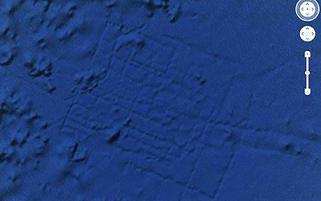
'Google-Earth
Update Eradicates Evidence of Atlantis':
A Google-Earth map
(Below) that raised
rumours of the lost city
of Atlantis off the
coast of Africa in 2009
has been updated,
eradicating the image in
the process. The images
appeared to show a
grid-like pattern on the
seafloor which some
believed were sunken
streets from the
mythological underwater
city. The official
explanation for it is
that they are trawler
lines.
Spain -
Using satellite photography,
ground-penetrating radar and underwater
technology, a team of experts (led by
University of Hartford professor and
archaeologist Richard Freund) has been
surveying marshlands in Spain to look for
proof of an ancient city. The team have been
attempting to match geological formations to
Plato's descriptions and date artefacts back
to the time of Atlantis.
Greece -
Archaeologists
surveying the world�s oldest submerged town
have found ceramics dating back to the Final
Neolithic. Their discovery suggests that
Pavlopetri, off the southern Laconia coast
of Greece, was occupied some 5,000 years ago
� at least 1,200 years earlier than
originally thought.
South England -
Excavations of an underwater Stone Age archaeological
settlement dating back 8,000 years took place at the National
Oceanography Centre, Southampton between 30 July � 3 August
2007.
The coast of Morocco -
Single stones recorded, each one
larger than 'two-storey houses', have been discovered incorporated into a
wall extending for 9 miles under the sea.
(1)
Loch Ness, Scotland
- A Sonar scan revealed the presence of underwater prehistoric stone
ruins. (1)
Bahamas
- The famous 'Blue holes', with underwater
stalactites and stalagmites.
(1)
Yucatan and Belize -
Ancient Mayan roads continue out
from the coast to destinations undersea.
(1)
North of Venezuela -
An underwater wall was found that
extends for at least a hundred miles.
(1)
Madeira - It was on
the 'Ampere Seamont', north of Madeira that a Russian expedition
reported in 1977 that underwater photographs showed pictures of
walls, pavements and steps. (1)
The coast of France
- Out in the Mediterranean, in front of Marseille, the passages of
an underwater cliff have revealed a series of mine shafts and
smelting facilities. (1)
The coast of Georgia
- There is another long and wide
underwater road in the Atlantic off the coast of Georgia.
(1)
Jaques
Cousteau tells of having discovered a road along the sea bottom of
the Mediterranean. (1)
 The Bimini Road (right) is an underwater
formation near North Bimini island in the Bahamas. Discovered in
1968, it is generally assumed to be of natural origins. Some have
claimed that the formation is an ancient road, or perhaps a
collapsed wall.
The Bimini Road (right) is an underwater
formation near North Bimini island in the Bahamas. Discovered in
1968, it is generally assumed to be of natural origins. Some have
claimed that the formation is an ancient road, or perhaps a
collapsed wall.