|
Location:
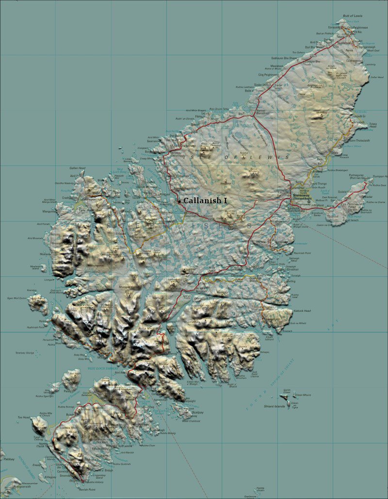
Isle of Lewis, Hebrides, Scotland.. |
Grid Reference:
58�
12' 12" N, 6� 45' 25" W. |
 Callanish I:
(Stone Circle, Avenues).
Callanish I:
(Stone Circle, Avenues).
One of the most spectacular megalithic sites in Scotland. The overall design
of the monument is similar to the Celtic cross and the cruciform chambers of
many Neolithic passage mounds.
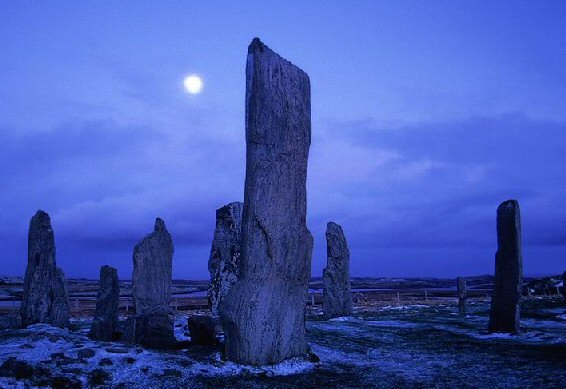
The Callanish-I stone-circle was built so that the moon, at its major
standstill appears to rise and set from behind the hills of Harris
which are as much a part of the monument as the stones themselves.
Callanish has been associated with both lunar and solar astronomy.
(Click here for
Map of Location)
('Calanais', 'Tursachen',
'The Place of Mourning/Pilgrimage).
Construction of the site took
place between 2900 and 2600 BC, though there were possibly
earlier buildings before 3000 BC. A tomb was later built into
the site. Debris from the destruction of the tomb suggests the
site was out of use between 2000 BC and 1700 BC.
(1)
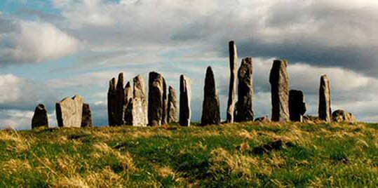
The stones vary from around 1 m to 5 m in height, with an average of 4 m,
and are of the local Lewisian gneiss. The site centres on a natural peak in
the landscape, offering spectacular views all round.
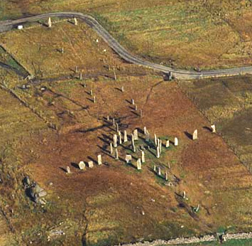
Callanish I consists of a 13.1 x 11.3m (43 x 37 ft)
circle of 13 gneiss stones. In the centre stands a monolith (4.75m/15 ft 6
in). Four avenues lead away, with single rows of stones to the east,
south and west, and a double row just east of north. Had all the rows been
completed, their axial alignments would have converged at the centre stone.
The Stone is all local Lewissean gneiss.
Inside the
circle are the remains of a chambered round cairn of Neolithic type, within
which human bones were found, this is commonly suggested to have been a
secondary feature. The
stones were buried in peat up to about 5 ft high before
they were cleared in the year 1857.
Alignments:
Professor
Alexander Thom finds that looking south along the line of the stone avenue
gives the point at which midsummer full moon sets behind Clisham.
Also
running from the circle are single lines of stones to the east (4 stones),
west (4) and south (6). In plan, the site has the form of a cross.
Running north from the stone circle are two parallel lines of stones forming
an avenue about 80 metres long. There are now 19 stones in the avenue. Any
visitor entering the site from the north will feel impelled to walk up this
avenue to the circle, although this is now discouraged.
More
recently researchers have suggested that the avenue
should be viewed as pointing south, to the position of the setting southern
moon at the major standstill, though the horizon is blocked by the rocky
knoll to the south of the site. The southern line of stones together with
the large monolith in the centre of the circle has a bearing of 180.1�, and
is an accurate indicator of the meridian, true north-south. Such a line
indicates to the north the 'pole' around which the stars of the night sky
appear to revolve, and to the south the highest position the sun and moon
attain in the sky on any day.
Callanish I is just one of over twenty megalithic sites on Lewis.
The stones are intricately connected to the landscape, as with many megalithic
ceremonial complexes. in the case of
Callanish I, the stones share an intimate relationship with both the range of hills known as
the 'sleeping beauty' or the 'old woman of the moors'. When the moon reaches
it's southern extreme each 18.6 years it is seen to rise from
behind the sacred hill range and skim the horizon for four hours till it
gently sets again behind the Harris hills. This range of hills are as much a
part of the monuments as the stones themselves.
The central stone bears a strong similarity to those on the
Orkneys.
The relationship between the stones and the landscape can be seen to
have been an important consideration to the builders, in Scotland and
beyond. This is especially the case with the larger civil-scale
ceremonial complexes of western Europe.
(More about
Neolithic Ceremonial Complexes)
Astronomy at Callanish:
The Callanish stones are situated at latitude 58� 12' north,
which is exactly the right latitude for picking up the lunar standstills at
their most southerly positions against the hills on the horizon, an event
which only happens once each 18.6 years. It is worth pointing out too that
at this latitude during the major lunar standstills north the Moon hardly
sets, an observation which is echoed in Diodorus' famous text concerning the
Temple of Apollo on the Isle of the Hyperborean's.
Extract: Aubrey Burl's revised
'Stone Circles of Britain, Ireland and Brittany'.
'As soon as I read about Apollo skimming the earth I knew
this couldn't be Stonehenge, because at Stonehenge's latitude both the sun
and the moon are always very high above the horizon. To see that phenomenon
(the moon or sun hardly rising above the horizon between rising and setting)
you have to go about 500 miles further north, and I wondered if Diodorus
might have been referring to Callanish.
Then Diodorus goes on to say: 'In that temple, at the rising of the
Pleiades, the sun is seen to set at the equinox'. And those two phenomena do
also occur uniquely at Callanish. The ENE stone row at Callanish was in line
with the rising of the Pleiades in the early Bronze Age, and the western
stone row does point towards the setting of the sun at the equinox. So three
independent lines of astronomical evidence point to Callanish; and that is
very convincing.
It is accepted that Diodorus took his information about Britain from the
earlier, lost, writer Hecataeus of Abdera, who himself drew on the lost
writings of the 4th century BC Greek explorer Pytheas. Now what is
remarkable is that by the time Pytheas got to Callanish, the Pleiades would
have risen a few degrees to the north-east of the ENE stone row. The
Pleiades - whose movements can be dated - had risen in alignment with the
row for a few centuries after about 1700 BC (which is presumably when the
row was built), but since then had edged away.
So Pytheas seems to have been reporting a folk memory of the connection
between the circle and the Pleiades that had survived at Callanish for at
least 1,000 years, long after the circle had gone out of use. This may seem
incredible but we know from other societies that oral traditions can survive
for many, many centuries even though their original use has long since been
abandoned.
Strangely enough, years later when I wrote a book about stone rows, I
suggested - quite independently of Callanish - that short stone rows (the
type found at Callanish) were erected about 1800-1500 BC. And there you go,
the Pleiades are rising at Callanish right in the middle of that range'.
Much work has been done over the last 80 years on the astronomical
orientations built in to the monument at Callanish, some of which are still
controversial. Boyle Somerville suggested in 1913 that the northern avenue
was positioned to indicate the rising of the star Capella about 3,800 B.P.
He pointed out that the west row indicates the setting sun at the two
equinoxes. He also suggested that a line between the two stones outside the
circle (to the north-east and south-west) indicated the moon at its maximum
(major standstill). This was the first time a surveyor introduced evidence
for a lunar line for any prehistoric site in Scotland.
(Other Examples of Prehistoric
Astronomy)
|
Callanish: It's place on prehistoric Britain's geodetic map.
Callanish is connected through geometry to other
important British megalithic sites.
It is curious fact that several of
the most prominent British megaliths are also related to each other
through 'geodesy', a statement which makes the blood run cold in
mainstream historians. However, whether through accident or design, it
is a fact that Callanish is situated exactly 5� North and 5� West of
Arbor low, which is said to be a 'centre of ley-activity', and
which in turn can be seen to be related through exact degrees to some of
the most important megaliths in England.
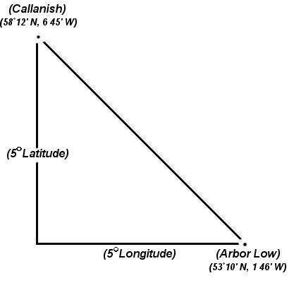
Callanish sits 5 �
North of Arbor Low, and 5�
West..
Arbor Low (53� 10' N, 01� 46' W),
Callanish (58�
12' N, 6�
45' W).
Arbor-Low is in turn related to
several other significant prehistoric monuments, revealing the
possibility that certain sites may have been located according to a
working knowledge of both latitude (calculated on the altitude of the
pole-star for example) and more importantly, longitude - which is
notoriously difficult and the cause of resistance to such ideas.
 . .
Arbor Low is positioned
exactly 1 �
East
of Glastonbury Tor and 2�
North.
Arbor Low (53� 10' N, 01� 46' W),
Glastonbury Tor (51�
09' N, 2� 45' W).
This means that Callanish lies 7� North of Glastonbury and 4�
West.
(Click here for more about English geodesy)
(Geodesy Homepage)
|
Tradition and Myth:
A tradition still current in the twentieth century called for all the fires
on the island of Lewis to be extinguished on My first (Beltane). Priest's
then started a new ire and distribute it to any people within the circle.
This suggests an association with the sun-god Baal (Bel). Other traditions
explain the presence of these stones by saying that when giants of old who
then lived on the island refused to be Christianised, St.Kieran turned them
to stone. Another local belief of this Gaelic-speaking community was that
when the sun rose on midsummer morn, the 'shining one' walked along the
stone avenue, his arrival heralded by the cuckoo's call. This could be a
remnant of the astronomical significance of the Callanish stones.
(Stone Circles)
(Archaeoastronomy)
(Megalithic Complexes)
(Prehistoric British Geodesy)
(Other
Prehistoric Scottish Sites)
(Additional Information about Callanish at SacredSites.com)
|